1 min read
Apollo 17 Landing Region

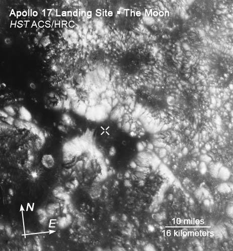
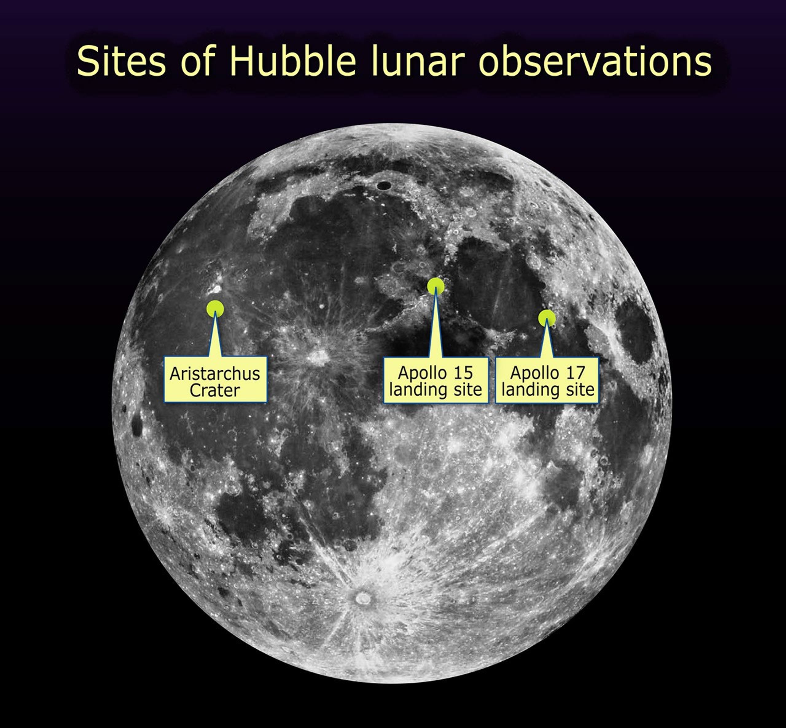
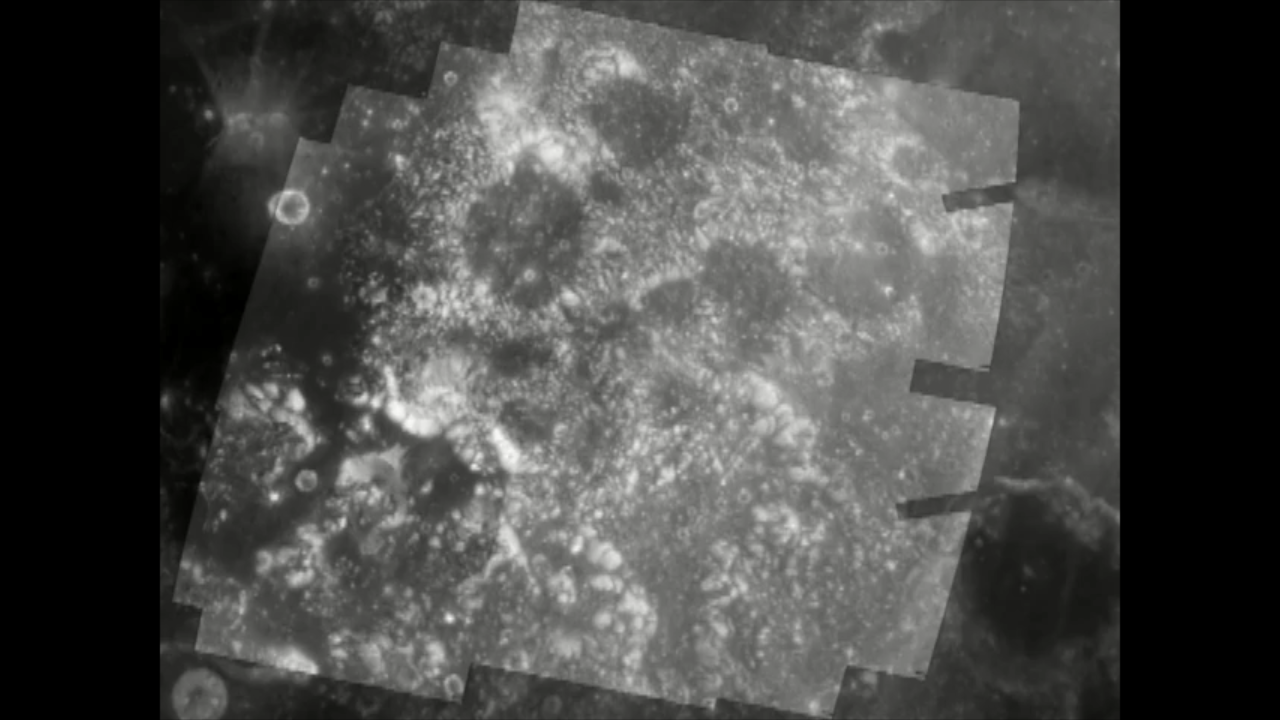
This image showcases Hubble Space Telescope's first high-resolution ultraviolet and visible imaging of the Apollo 17 landing region within the Taurus-Littrow valley of the Moon. Humans last walked and drove on the lunar surface in this region (marked "+" in the image at left and at lower right) in December 1972.
The image at upper right was taken by the Apollo 17 astronauts (Dr. H. Jack Schmitt and Gene Cernan). It illustrates a view of the rim of Shorty crater and the lunar roving vehicle against a backdrop of the mountain-like massifs that define the Taurus-Littrow valley. The Hubble Space Telescope image at lower right was constructed by overlaying the Hubble image (at left) with a digital-terrain model acquired by the Apollo program to provide a perspective view looking from west to east up the valley. These Hubble data illustrate the high-resolution resolving power of the Advanced Camera for Surveys and display features smaller than a soccer field from low-Earth orbit some 248,000 miles (400,000 kilometers) distant. These images were acquired at nearly full Moon, so the long, dark shadows typical of many lunar orbital photos are not seen; however, this is perfect lighting for color analysis from which to interpret subtle compositional differences.
The Hubble Space Telescope Lunar Exploration team is using the Apollo 17 images (and those acquired of the Apollo 15 site) as "ground-truth" in an effort to discriminate lunar materials enriched in ilmenite, a titanium-bearing oxide of potential value as a resource in human exploration of the Moon.
The images at left and at lower right were taken Aug. 16, 2005 by Hubble's Advanced Camera for Surveys. North is at the top in these images.
Images were processed by the Hubble Space Telescope Lunar Exploration team at NASA's Goddard Space Flight Center, Northwestern University, and the Space Telescope Science Institute.
About the Object
- DistanceDistanceThe physical distance from Earth to the astronomical object. Distances within our solar system are usually measured in Astronomical Units (AU). Distances between stars are usually measured in light-years. Interstellar distances can also be measured in parsecs.The Moon is 238,857 miles (384,403 kilometers) from the Earth.
- DimensionsDimensionsThe physical size of the object or the apparent angle it subtends on the sky.The Moon has a diameter of 2160 miles (3476 kilometers).
About the Data
- Data DescriptionData DescriptionProposal: A description of the observations, their scientific justification, and the links to the data available in the science archive.
Science Team: The astronomers who planned the observations and analyzed the data. "PI" refers to the Principal Investigator.These HST data are from proposal 10719. NASA's HST Lunar observation team is led by Chief Scientist J. Garvin. The team includes M. Robinson (Northwestern Univ.), D. Skillman (NASA/GSFC), B. Hapke (Univ. of Pittsburgh), C. Pieters (Brown Univ.), M. Ulmer (Northwestern Univ.), J. Bell (Cornell Univ.), and J. Taylor (Univ. of Hawaii). - InstrumentInstrumentThe science instrument used to produce the data.HST>ACS/HRC (left and bottom right), and Apollo 17 (top right)
- Exposure DatesExposure DatesThe date(s) that the telescope made its observations and the total exposure time.August 16, 2005 (HST), and December 1972 (Apollo 17)
- FiltersFiltersThe camera filters that were used in the science observations.HST: F250W (250nm), F344N (344nm), F502N (502nm), F658N (658nm)
- Object NameObject NameA name or catalog number that astronomers use to identify an astronomical object.moon
- Object DescriptionObject DescriptionThe type of astronomical object.Earth's Satellite
- Release DateOctober 19, 2005
- Science ReleaseNASA’s Hubble Looks for Possible Moon Resources
- Credit
Related Images & Videos

Aristarchus Plateau on the Moon
The Hubble Space Telescope Advanced Camera for Surveys imaged Aristarchus crater and nearby Schroter's Valley rille on Aug. 21, 2005. The Hubble images reveal fine-scale details of the crater's interior and exterior in ultraviolet and visible wavelengths at a scale of...

Hubble Reveals Potential Titanium Oxide Deposits at Aristarchus and Schroter's Valley Rille
This view of the lunar impact crater Aristarchus and adjacent features (Herodotus crater, Schroter's Valley rille) illustrates the ultraviolet and visible wavelength characteristics of this geologically diverse region of the Moon. The two inset images illustrate one preliminary...

Aristarchus Plateau in Ultraviolet Light
The Hubble Space Telescope Advanced Camera for Surveys imaged Aristarchus crater and nearby Schroter's Valley rille on Aug. 21, 2005. The Hubble images reveal fine-scale details of the crater's interior and exterior in ultraviolet and visible wavelengths at a scale of...

Schroter's Valley Rille in False Color
This color-composite focuses on a section of Schroter's Valley (rille) and employs ultraviolet- to visible-color-ratio information to accentuate differences that are potentially diagnostic of ilmenite- (i.e, titanium oxide) bearing materials as well as pyroclastic glasses. Bluer...

Aristarchus Crater in False Color
This color composite focuses on the 26-mile-diameter (42-kilometer-diameter) Aristarchus impact crater, and employs ultraviolet- to visible-color-ratio information to accentuate differences that are potentially diagnostic of ilmenite- (i.e, titanium oxide) bearing materials as...

Hubble View of Apollo 17 Landing Region on the Moon
This image showcases Hubble Space Telescope's first high-resolution ultraviolet and visible imaging of the Apollo 17 landing region within the Taurus-Littrow valley of the Moon. Humans last walked and drove on the lunar surface in this region (marked "+" in the image) in...

Hubble Image Overlaid on Modeling of Apollo 17 Landing Site
This image was constructed by overlaying the Hubble Advanced Camera for Surveys image of the Apollo 17 landing region within the Taurus-Littrow valley, taken on Dec. 16, 2005, with a digital-terrain model acquired by the Apollo program to provide a perspective view looking from...

Apollo 17 Astronaut's Snapshot of Taurus-Littrow Valley
This image was taken by the Apollo 17 astronauts (Dr. H. Jack Schmitt and Gene Cernan). It illustrates a view of the rim of Shorty crater and the lunar roving vehicle against a backdrop of the mountain-like massifs that define the Taurus-Littrow valley.

A Close-Up View of the Aristarchus Crater
The Hubble Space Telescope's Advanced Camera for Surveys snapped this close-up view of the Aristarchus crater on Aug. 21, 2005. The crater is 26 miles (42 kilometers) in diameter and approximately 2 miles (3.2 kilometers) in depth, and sits at the southeastern edge of the...

Hubble's View of the Apollo 17 Landing Site
This image of the Taurus-Littrow valley shows the Apollo 17 landing site (the "+" symbol in the image). This region marks the last time – December 1972 – that humans walked and drove on the Moon's surface. Astronomers are using the Apollo 17 images (and those of the Apollo 15...

An Astronaut's Snapshot of the Moon
Apollo 17 astronauts Dr. H. Jack Schmitt and Gene Cernan took this image of the Moon's Taurus-Littrow valley. The view shows the lunar roving vehicle near the rim of Shorty crater. In the distance are the mountain-like massifs that define the Taurus-Littrow valley. This region...

NASA News Conference: Lunar Prospecting with Hubble (Webcast)
NASA hosted a news conference October 19th, 2005 at 1pm to discuss new Hubble Space Telescope images of the moon's surface in ultraviolet light. Hubble's resolution and sensitivity to ultraviolet light have allowed the telescope to search for important oxygen-bearing minerals on...

Aristarchus Site w/ Color Overlay – 3D Topography
A 3-dimensional topography where Hubble's Advanced Camera for Surveys data was overlaid on top of the modeling using Clementine and Apollo data of the Aristarchus Valley. A fly through of the valley starts with the Aristarchus crater and then Schroter's Valley rille. The...


Share
Details
Claire Andreoli
NASA’s Goddard Space Flight Center
Greenbelt, Maryland
claire.andreoli@nasa.gov