


Search Landsat
Filters

A massive, old caldera and more recently formed craters shape the landscape in the eastern Sierra Nevada.

Scientists pioneered a new system that combines data from multiple Earth-observing satellites to identify forest clearing up to 100 days earlier than current methods.

The February 2026 eruption at Piton de la Fournaise has lasted longer and produced a larger volume of lava than recent eruptions from this frequently active volcano.
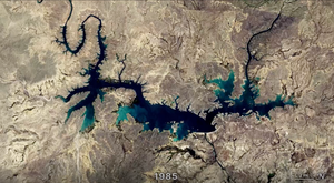
In two recent studies, researchers used Landsat data to fill key gaps in our knowledge of reservoir structure and dynamics.

A network of meltwater lakes and drainage channels made an Antarctic ice shelf known for its blue ice areas even bluer.

The activity of herring around Vancouver Island in British Columbia brightened coastal waters enough to be detectable from space.

Back-to-back subtropical cyclones in March fueled destructive flash flooding on several of the Hawaiian Islands.

Plains around the San Andreas Fault and across Carrizo Plain National Monument are awash with yellow as wildflowers bloom.

Episode 43 of the Hawaiian volcano’s current eruption was marked by high lava fountains and widespread ash dispersal.

Ireland is best known for its many greens, but the striking grays of the island's Burren region also stand out in satellite images.