


Search Landsat
Filters

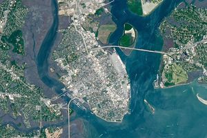
The city's metro area has pushed westward since it last hosted World Cup matches in 1986, expanding across a landscape shaped by ancient volcanoes.
Landsat’s Jim Irons won the prestigious William T. Pecora Award. Irons, now an emeritus scientist at NASA Goddard Space Flight Center, played an integral role in shaping the Landsat program into what it is today.

Once below a shallow sea, Jabal al Fāyah now stands above the desert in the United Arab Emirates as a reminder of a watery past and early human survival.

A wildland fire charred grassland, coastal sage scrub, and chaparral across one-third of the island, the second largest of the Channel Islands.

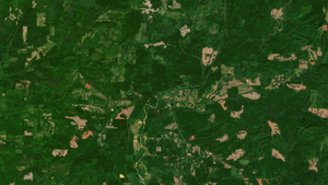
Wild disturbances are on the rise, while land disturbed by human activity has been decreasing.
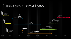
The Landsat 10 Spacecraft Draft Request for Proposal (DRFP) is available for review via SAM.gov.

The volcano on Indonesia’s Halmahera Island routinely ejects ash, volcanic gases, and volcanic bombs.
DIST-ALERT, a global land change monitoring system, is revolutionizing forest management.

Once a month during the full Moon, Landsat 9 turns from Earth to image the lunar surface, helping keep the spacecraft's data accurate and consistent.
In a precursor to Memorial Day, people in Charleston, South Carolina, honored fallen Civil War troops with flowers, songs, and marches at an event at a racetrack on May 1, 1865.