1 min read
Seasonal Changes in Mars’ North Polar Ice Cap
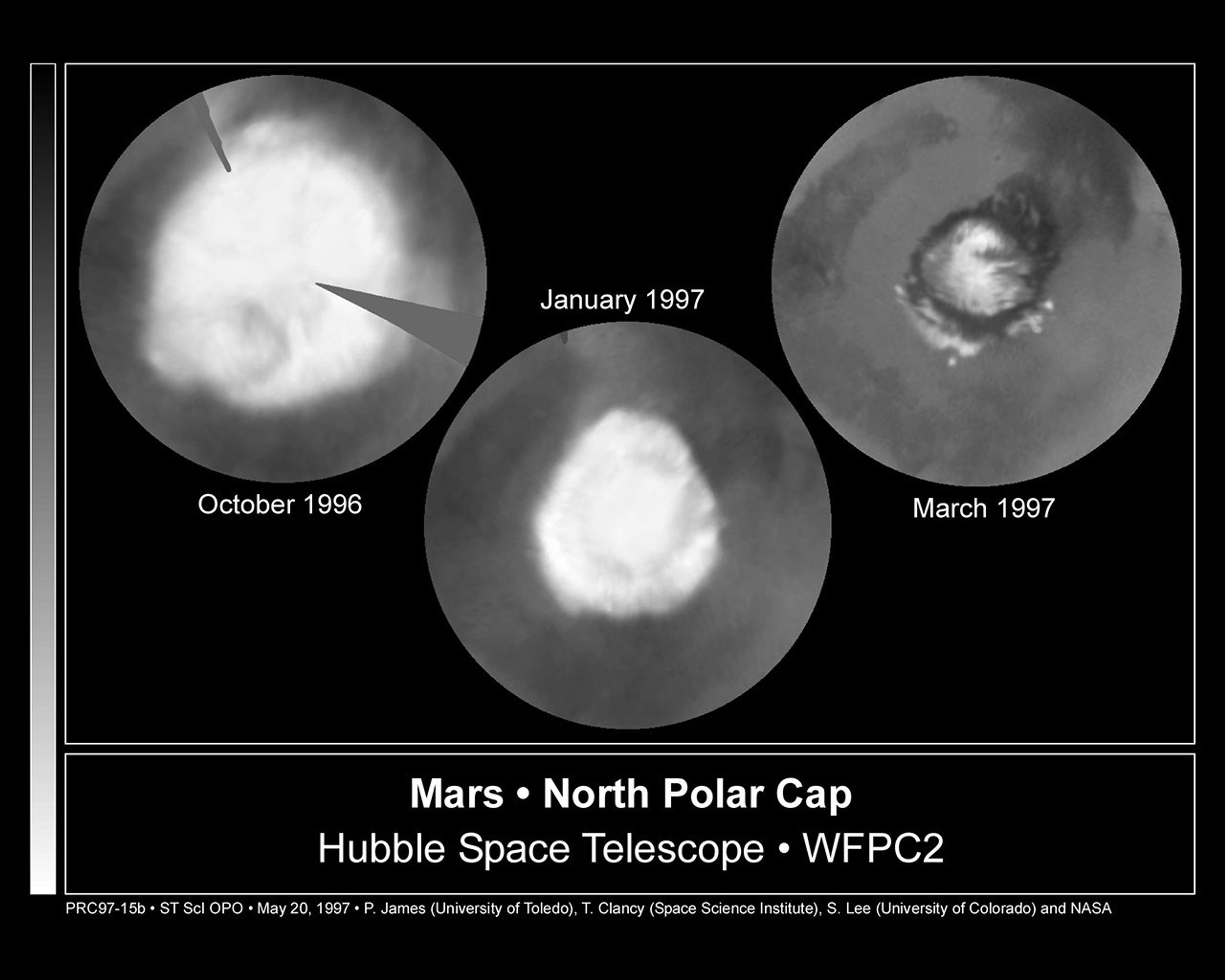
These images, which seem to have been taken while NASA's Hubble Space Telescope (HST) was looking directly down on the Martian North Pole, were actually created by assembling mosaics of three sets of images taken by HST in October, 1996 and in January and March, 1997 and projecting them to appear as they would if seen from above the pole. This first mosaic is a view which could not actually be seen in nature because at this season a portion of the pole would have actually been in shadow; the last view, taken near the summer solstice, would correspond to the Midnight Sun on Earth with the pole fully illuminated all day. The resulting polar maps begin at 50 degrees N latitude and are oriented with 0 degrees longitude at the 12 o'clock position. This series of pictures captures the seasonal retreat of Mars' north polar cap.
October 1996 (early spring in the Northern hemisphere): In this map, assembled from images obtained between Oct. 8 and 15, the cap extends down to 60 degrees N latitude, nearly it's maximum winter extent. (The notches are areas where Hubble data were not available). A thin, comma-shaped cloud of dust can be seen as a salmon-colored crescent at the 7 o'clock position. The cap is actually fairly circular about the geographic pole at this season; the bluish "knobs" where the cap seems to extend further are actually clouds that occurred near the edges of the three separate sets of images used to make the mosaic.
January 1997 (mid-spring): Increased warming as spring progresses in the northern hemisphere has sublimated the carbon dioxide ice and frost below 70 degrees north latitude. The faint darker circle inside the cap boundary marks the location of circumpolar sand dunes (see March '97 map); these dark dunes are warmed more by solar heating than are the brighter surroundings, so the surface frost sublimates from the dunes earlier than from the neighboring areas. Particularly evident is the marked hexagonal shape of the polar cap at this season, noted previously by HST in 1995 and Mariner 9 in 1972; this may be due to topography, which isn't well known, or to wave structure in the circulation. This map was assembled from WFPC2 images obtained between Dec. 30, 1996 and Jan. 4, 1997.
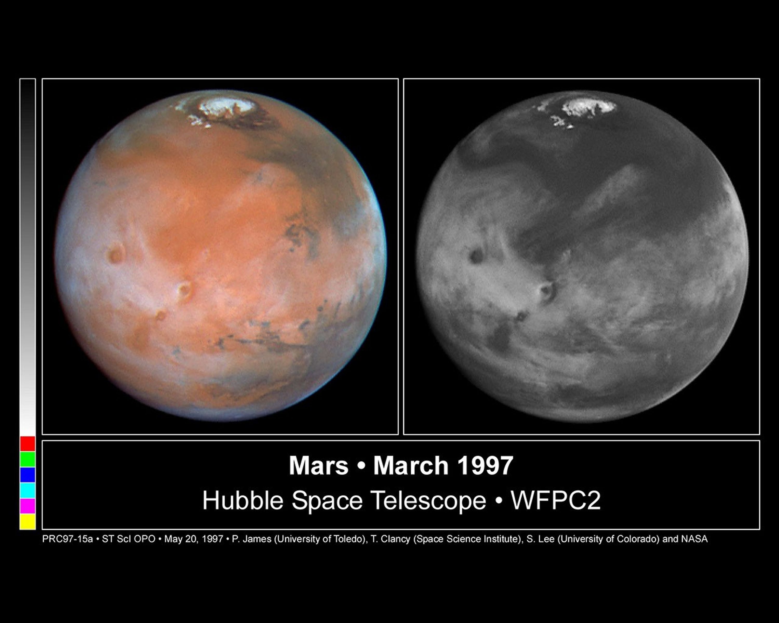
March 30, 1997 (early summer): The cap has fully retreated to its remnant core of water-ice. This residual cap is actually almost cut into two by a large, horn-shaped canyon called Chasma Borealis which is cut deeply into the polar terrain. The HST images also reveal a curious layered terrain which is evidence of past climatic changes on Mars. The sublimation of all of the carbon dioxide has exposed the ring of dark sand dunes which encircle the North Polar Cap. Outliers of ice persist south of the polar sand sea (between the 3 o'clock and 9 o'clock positions). The bright circular features at 3, 6, and 9 o'clock are ice-filled craters.
All images were taken with the Wide Field and Planetary Camera 2. The color is constructed from images taken in red (673 nm) , blue (410 nm) and green (502 nm) light. The resolution at the North Pole ranges from about 115 km/pixel in October '96 to about 45 km/pixel in March '97.
About the Object
- DistanceDistanceThe physical distance from Earth to the astronomical object. Distances within our solar system are usually measured in Astronomical Units (AU). Distances between stars are usually measured in light-years. Interstellar distances can also be measured in parsecs.At the 1997 Mars opposition, the planet was approximately 62 million miles (100 million kilometers) from Earth.
- DimensionsDimensionsThe physical size of the object or the apparent angle it subtends on the sky.The planet has a diameter of 4,222 miles (6,794 km) at the equator.
About the Data
- InstrumentInstrumentThe science instrument used to produce the data.HST>WFPC2
- Exposure DatesExposure DatesThe date(s) that the telescope made its observations and the total exposure time.October 8 and 15, 1996, and January and March, 1997
- FiltersFiltersThe camera filters that were used in the science observations.410 nm, 502 nm, and 673 nm
- Object NameObject NameA name or catalog number that astronomers use to identify an astronomical object.Mars
- Object DescriptionObject DescriptionThe type of astronomical object.Planet
- Release DateMay 20, 1997
- Science ReleaseHubble Finds Cloudy, Cold Weather Conditions for Mars-Bound Spacecraft
- CreditPhil James (Univ. Toledo), Todd Clancy (Space Science Inst., Boulder, CO), Steve Lee (Univ. Colorado), and NASA
Blue: 410 n nanometers Green: 502 nanometers Red: 673 nanometers
Related Images & Videos
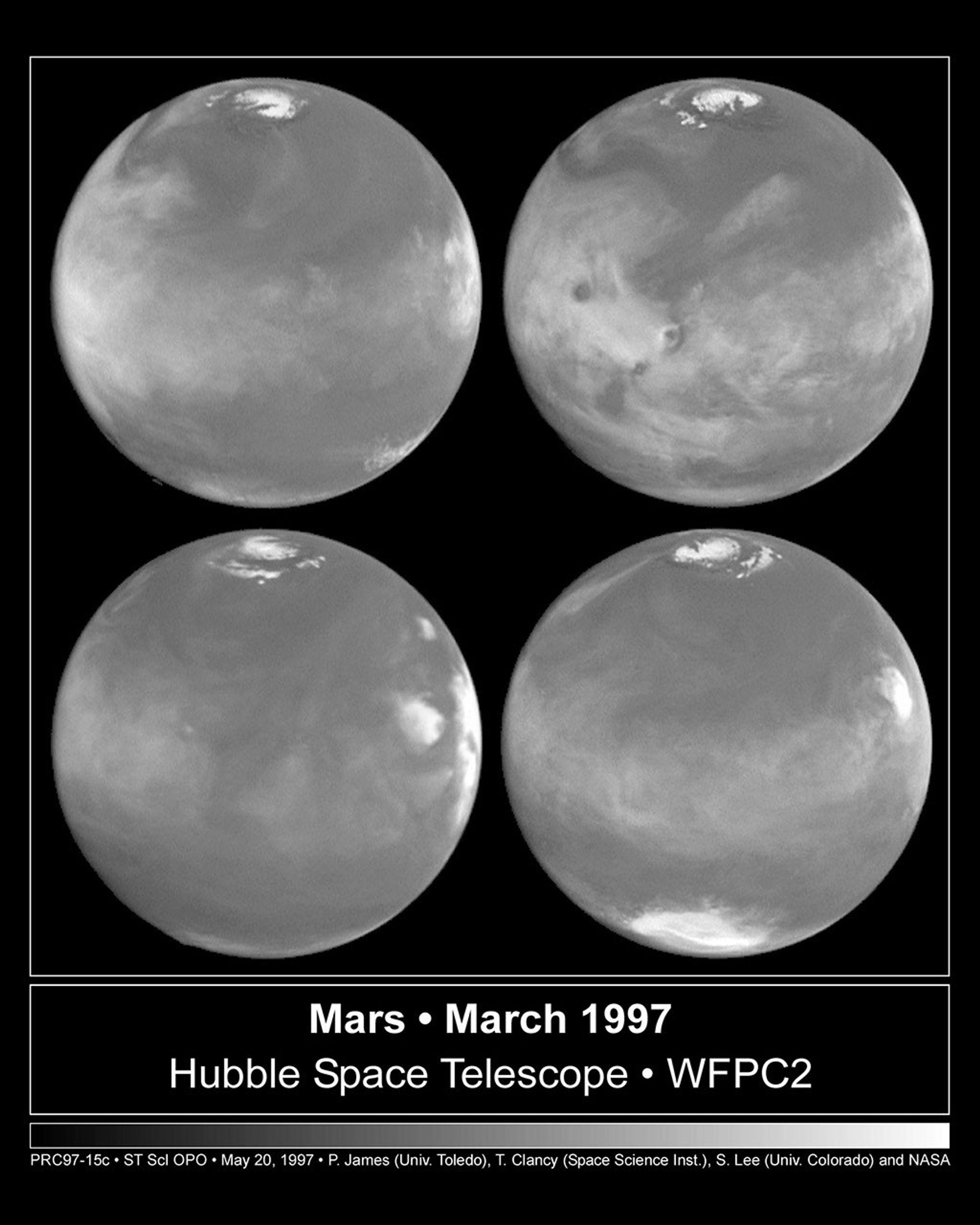
Four View of Mars In Northern Summer
Four faces of Mars as seen on March 30, 1997 are presented in this montage of NASA Hubble Space Telescope images. Proceeding in the order upper-left, upper-right, lower-left, lower-right, Mars has rotated about ninety degrees between each successive time step. For example the...
Seasonal Changes in the Martian North Polar Ice Cap
These views from above the Martian pole were assembled from mosaics of three sets of images and projected to appear as if from above. This series captures the seasonal retreat of the polar cap from its greatest extent of the year (October, 1996) at 60 degrees N latitude through...
Hubble and Viking Views of the Pathfinder Landing Site, July 4, 1997
Pathfinder is landing on the Ares Valles, shown at the center of a Hubble Space Telescope full-color disk of Mars. The next map is a closeup of the Hubble image, and finally the Viking image shows the terrain near the Mars Pathfinder landing site, marked by an oval.
Share
Details
Claire Andreoli
NASA’s Goddard Space Flight Center
Greenbelt, Maryland
claire.andreoli@nasa.gov