Suggested Searches

The Latest in NASA Science News

The latest news briefs from NASA science.

    NASA Missions Help Identify What Powers Auroral ‘Space Battery’

    An arc of green aurora bends over the limb of Earth, which appears cloudy. A faint red haze appears above the green auroral arc against the black background of space.

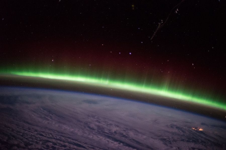
    Scouring archived observations from NASA missions, scientists may have solved a mystery about what powers a type of aurora called auroral arcs. The answer, they say, is space waves. From the ground, auroral arcs look like green, glowing curtains of light sweeping across the night sky. From space, they appear as thin, green lines — or arcs — slicing across the […]

    Read Full Post

    NASA’s Galileo Mission Points to Ammonia at Europa, Recent Study Shows

    A high-resolution scientific graphic from NASA illustrates the detection of ammonia on the surface of Jupiter’s moon, Europa. On the left, a full-disk view of the icy moon is shown against a black starfield, with a white rectangular box highlighting a specific region near the equator. This box zooms into a large, detailed grayscale map on the right, which reveals a complex landscape of crisscrossing linear ridges and fractured "chaos terrain." Overlaid on this topographical map are pixelated data clusters: purple areas indicate the presence of ammonia, while vibrant red pixels mark the highest concentrations. These detections are primarily concentrated along the geologically active ridges and disrupted ice, suggesting that the ammonia may be surfacing from the moon's subsurface liquid ocean.

    New analysis of decades-old data has turned up a significant result: the first discovery of ammonia-bearing compounds on the surface of Jupiter’s moon Europa. Ammonia is a nitrogen-bearing molecule, and nitrogen — like carbon, hydrogen, and oxygen — is key to life as we know it. As the first such detection at Europa, the finding […]

    Read Full Post

    NASA-French SWOT Satellite Provides Global Estimate of River Discharge

    A map of the Earth with blue and green lines

    Science teams at NASA and the French space agency CNES (Centre National d’Études Spatiales) have released the first-ever global estimate of river discharge and suspended sediment, as observed from space, marking a new milestone in our ability to understand one of Earth’s most fundamental systems. Developed using data from the SWOT (Surface Water and Ocean […]

    Read Full Post

    NASA Instrument Reveals New Ability to Gather Nighttime Light Data

    A darkened image of the continental US with spots of light ranging in intensity and color.

    NASA’s Tropospheric Emissions: Monitoring of Pollution instrument, or TEMPO, is known for measuring trace gases like nitrogen dioxide, ozone, and formaldehyde in the air we breathe. Now TEMPO has a new trick. It can see in the dark. Since launching in 2023, TEMPO data has set a record at the Atmospheric Science Data Center (ASDC) […]

    Read Full Post

    NASA and Partners Expand Crucial Water Tracking Program

    The 48 contiguous United States with color coding to reveal water evapotranspiration.

    All 48 contiguous United States will now benefit from timely, high-resolution water data. The OpenET program, a public-private collaboration led by consortium partners NASA, the U.S. Geological Survey, California State University Monterey Bay, Environmental Defense Fund, Desert Research Institute, Google Earth Engine, and HabitatSeven, provides information on evapotranspiration. Evapotranspiration is the movement of water from […]

    Read Full Post

    NASA Satellite Data Could Soon Lead to Safer Bridges Worldwide

    Researchers are turning to satellite data to monitor the world’s longest bridges. Due to high costs and logistical challenges, fewer than 1 in 5 bridges extending 492 feet (150 meters) or more have systems installed to track structural changes that might be harbingers of damage or danger. Satellites could more than triple the portion of […]

    Read Full Post

    NASA’s Parker Solar Probe Helps Map Sun’s Outer Boundary

    The Sun appears as a glowing yellow ball at the center. Surrounding it are petal-like features in blue with squiggly white outlines. Near the center to the right of the Sun appears the Parker Solar Probe spacecraft.

    With the help of NASA’s Parker Solar Probe, astronomers have made the first continuous, two-dimensional maps of the outer edge of the Sun’s atmosphere. At this boundary, which scientists call the Alfvén surface, solar material escapes from the Sun to become the solar wind, a million-mile-per-hour stream of particles that flows outward in all directions across the solar system, striking planets, […]

    Read Full Post

    Hammering Out a Way to Find Shelter on the Moon and Mars

    A person holds a sledgehammer while wearing an orange safety vest and standing in an arid landscape while other people look on.

    With several hundred blows of a 10-pound (4.5-kilogram) sledgehammer, researchers tested a method to find subsurface caves that could serve as safe underground habitats and research facilities on the Moon and Mars. The team, which includes NASA scientists, conducted their field experiments near Flagstaff, Arizona, and Tulelake, California, in locations that resemble the landscapes future […]

    Read Full Post

    NASA Scientists Map Plant Productivity with Data from Ocean Satellite

    A map of North America changes colors showing how plant productivity moves further north as Northern Hemisphere winter progresses.

    NASA scientists have developed a new set of tools to monitor plant growth under various conditions throughout the growing season. The hope is that land managers could use these tools to detect sudden drops in plant productivity and to respond earlier to events like heat stress, droughts, and cold snaps. Monitoring the productivity, or how […]

    Read Full Post