Eric Vermote, Landsat Science Team Member, Wins Pecora Award
August 27, 2026
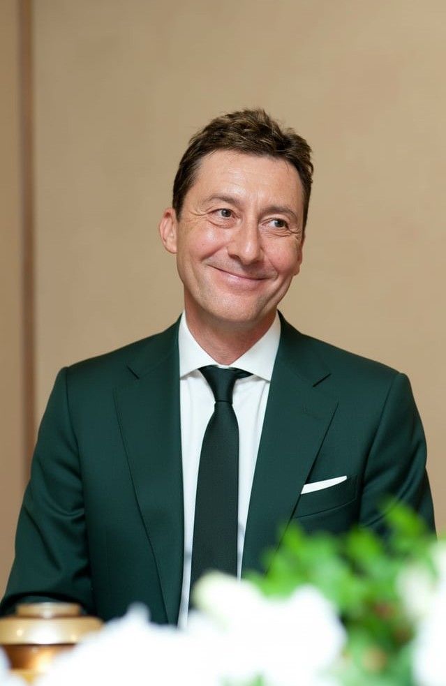
In May, Landsat Science Team member and atmospheric correction expert Eric Vermote won the William T. Pecora Award for his outstanding contributions set global standards for atmospheric correction and data validation.
Vermote has dedicated his career to improving the quality and reliability of Earth observation data. When optical satellites like Landsat observe the Earth, there’s one major obstacle in the way: the atmosphere. Removing atmospheric interference (like dust, water vapor, and aerosols) is key to getting a clear view of what’s happening on the ground. His pioneering work on the 6S radiative transfer code, an atmospheric correction algorithm, has been widely used by Earth observation missions to produce consistent and calibrated data over decades. As a member of the 2026-2030 Landsat Science Team, Vermote will continue to maintain and refine the Land Surface Reflectance Code (LaSRC), an atmospheric correction algorithm used for the Landsat 8, Landsat 9, Harmonized Landsat and Sentinel-2 (HLS) datasets, and prepare it for Landsat 10. Together, these algorithms allow data users to confidently compare observations taken across years and enable the creation of long-term global data records.
Vermote has been a key part of the Landsat program, including as a member of the Landsat Data Continuity Mission (LDCM) Science Team and the HLS Science Group. Across the wider agency, he is member of the Moderate Resolution Imaging Spectroradiometer (MODIS) Science Team and the NASA National Polar-orbiting Operational Environmental Satellite System Preparatory Project (Suomi NPP) Science Team for the VIIRS instrument. His foundational work is central to NASA’s commitment to providing the gold standard of Earth observation data
We spoke to Vermote about winning the Pecora Award, atmospheric correction, and the importance of calibration and validation:
Congratulations on the award. This is huge. How did you feel when you found out? Were you surprised?
Yeah, I was surprised. I thought that it was very unlikely that they would give it to a NASA guy this year. And then when I learned that Jim Irons got it too, I was like, wow, they gave it to two NASA guys. So, we should really be proud of the Agency.
Atmospheric correction isn't a household term, yet it's fundamental to so much of Earth observation science. How do you explain its importance to someone outside the field? Do you have a favorite analogy for helping people understand that challenge?
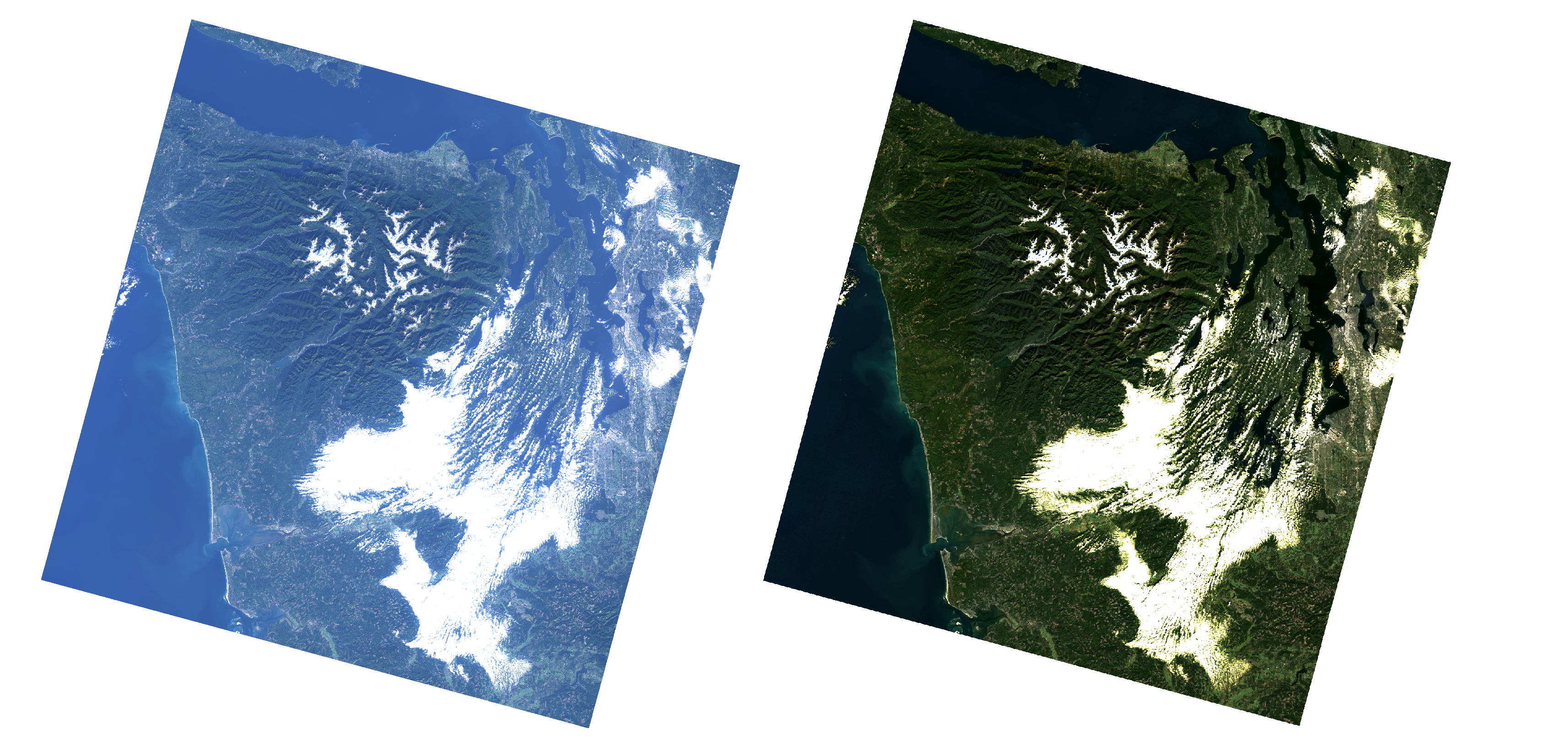
Well, I think that the best thing is just to show two pictures side to side, one without and one with atmospheric correction. Especially in true color. Even on a clear day, the one without atmospheric correction will be kind of blurry.
How does removing the atmospheric noise directly support real-world applications like agriculture, monitoring, and tracking environmental change?
First of all, for most applications you really need to know the properties of the land surface. If you’re looking at the Earth’s surface from space, you have an atmospheric signal and you cannot relate what you measure from space to what you measure on the ground. To get a pure signal from the ground surface you need to correct for the atmosphere. In an absolute sense, you need to get through the atmosphere to the land surface.
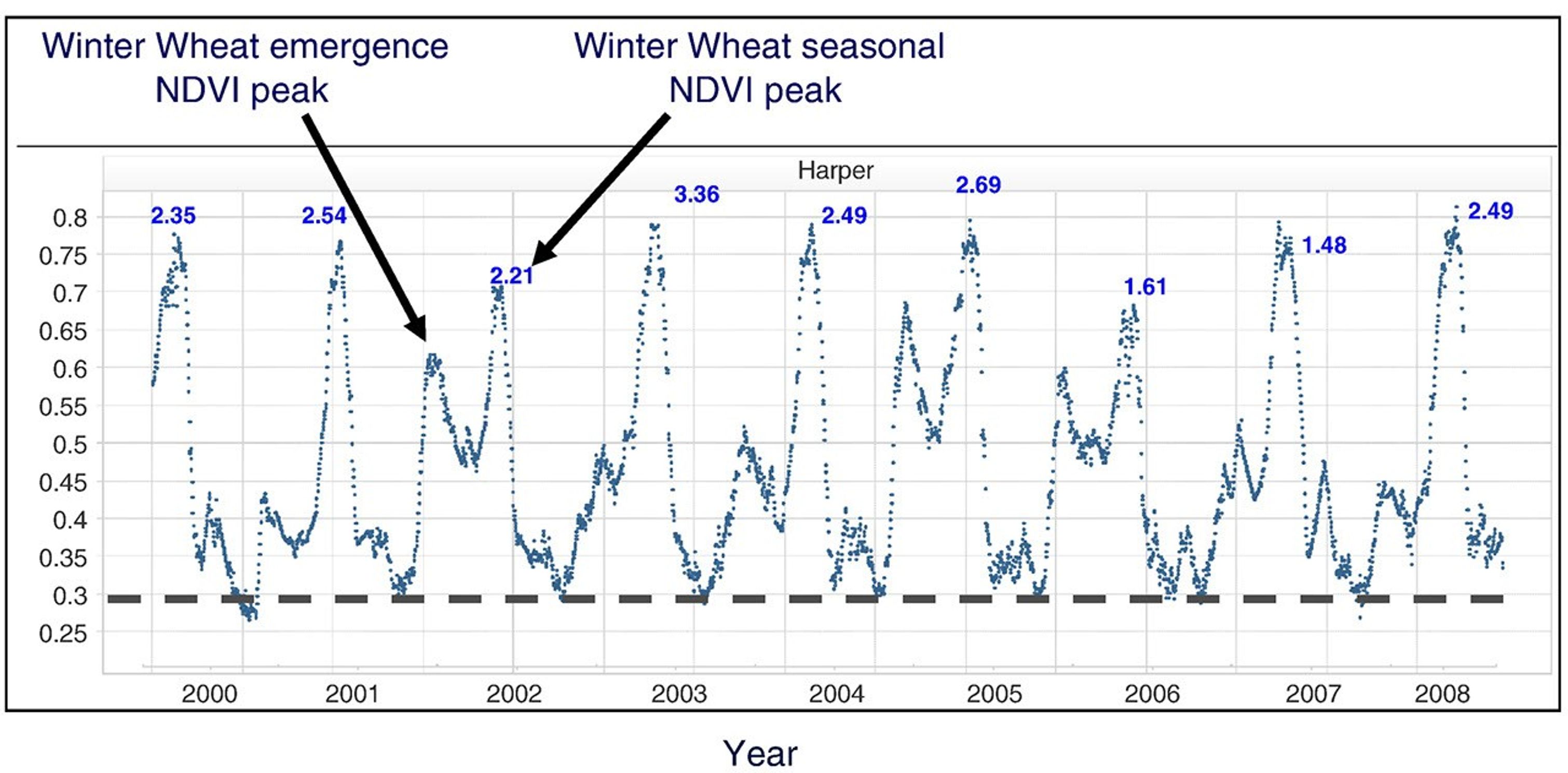
Also, the atmosphere varies from day to day for a variety of reasons. So, you will have noise in the time-series data that will prevent you from representing the evolution of the surface, such as the growth of crops (see figure below from Becker-Reshef et al., 2010, where data have been corrected for atmospheric effect and cloud screened).
So these two aspects, the absolute and the temporal that necessitate atmospheric correction.
Why are calibration and validation across decades of satellite observations so critical for understanding the changes on Earth's surface?
It's critical because, in a very simple example: to study land surface change over decades you will need to use data from multiple instruments. If you don't have accurate calibration, as you move from one instrument to another, you will see a change. I remember with the NOAA AVHRR series of satellites, I could look at all the AVHRR data and I could tell you, "Oh yeah, that's NOAA-7, that's NOAA-9, that's NOAA-11." They had their own signature because they were not calibrated. If you want to assemble a long-term consistent time series, it's critical to have a good calibration.
And of course, validation also is critical because without validation (accuracy assessment) there's nothing. I remember when we were first developing land products from MODIS, we were all excited, and had all these algorithms we had developed, they were superb. After a year or two of data, NASA said, "OK, now it's time to validate the products," and everybody went pale. We like to develop algorithms, but validating them is much more complicated and time-consuming. But at the end of the day, that's what brings you confidence in what you produce. There's no other way.
We often hear Calibration and Validation referenced together as Cal/Val. What is so different about a validation from calibration and why is that important?
Well, instrument calibration is usually at the first level. So, you go to data which are digital counts and you calibrate them into physical units (emissivity or reflectance). That's the first step. And from there you have a calibrated signal, but it's still raw. You don't have a product. So, if you want to look at the chlorophyll in the ocean, or vegetation composition on the land surface, you first need to do the atmospheric correction. And after that you need to come up with an algorithm to make a derived product. The final product could be chlorophyll content, for example, and you then need to validate it, or quantify the accuracy of the product. You can validate products by taking independent measurements on the ground and correlating them with what you have inverted from the signal. So, validation is one step beyond calibration. But you don't have validation without calibration. So that's why we always have Cal Val.
Your development of the 6S radiative transfer code for the land surface has become a standard across multiple missions. When you first developed these tools, did you imagine they would have such a broad and lasting impact?
No, no, I didn't. I mean, first of all, when I started my PhD there was the 5S code. The first thing they gave me was the manual for the 5S code and they said, because you're only starting in September, during your vacation, just read that. And I couldn't understand a word of it. I tried to read it. I had a vague idea of what I was working on.
When I did my PhD, I worked on 4 to 5 images, let's say 5. That's it. I never imagined that at some point I would work on so much data globally and be able to apply the code to global time-series.
Throughout your career, you've harmonized data across different sensors and agencies. What were the biggest challenges in making observations from different satellites truly comparable?
The first one is calibration. Instrument calibration specification is often around ±2%, and that means for the best sensors, if you're not lucky, measurements from two different sensors can differ by 4%. And the user usually wants less than 1%. So in harmonization, you need to choose a standard and you need to harmonize the calibration of every sensor. There is complication in that because they don't have the same spectral response, they don't have the same acquisition geometry. Differences in spectral response is a big challenge. You need to do things right from the beginning, and then harmonize them as much as you can, but not making them look alike. They really need to be harmonized in a very scientific and careful way. This should match at the end, but for good reason.
Your LaSRC code is currently used in the creation of the HLS product. In your eyes, why is the HLS data product so popular and important for the Earth Science community?
Because it brings the spatial resolution, the quality of the data, and the sensors it's composed of through harmonization, leading to a rich moderate resolution temporal time series. And it’s still very, very accurate. So for the user, it's something that they can readily use. It's truly ARD—analysis ready data—and users don't have to ask any questions. They just can use the data. They can trust it. And they have the high temporal resolution, the spatial resolution and the spectral resolution. They have a lot of things they can work with.
You've spent decades helping us see Earth's surface more clearly from space. What do you see as the next big frontier or challenge for atmospheric correction?
It's all in the details. We can talk about the coupling between the directional effect and the atmospheric effect, the atmospheric point spread function, things like that. Topography. That's the kind of thing we still need to improve. It's a second-tier effect, but people are going to want better and better data, so we're going to have to deal with it. In the past, we did not even have the computing capability to do those kinds of advanced corrections, so we didn't even try because there was no way to do it operationally. But nowadays, with all the advances in computing capability, we can envision doing those kinds of corrections.
Your work also involves collaboration with the AERONET network, an international partners to help establish common standards and validation methods. Why is international collaboration so important for Earth observation?
Take the example of AERONET. You need to put stations everywhere, not only near NASA Goddard. You need to put them in places where it's challenging to access and maintain the instruments. For every instrument in the network, you need a site manager. Even if it's the best instrument, sometimes you know there's a story of the spider in the tube, or the instrument just rotating too much and getting hung up on its own cable, or anything could happen. So you need somebody on site who can go check the instrument and that's usually an international partner. You cannot put some NASA employee at each site, although I would like to go to France and take care of an instrument. Laughs. When you have a global data set, you need a global network and international partners to implement it.
Increasingly we are dependent on international satellite data. By combining data from different satellites and harmonizing them, we increase the value for everybody, HLS is a good example using ESA Sentinel satellites. To get this right we need international collaboration and we increase the value of the data. With two instruments, it's more than twice an increase in value, you usually increase the value of both instruments and then get the value of the combination.
We've just started the next science team for Landsat this past spring. What impact do you think science teams have on the evolution of Earth observation from space?
A lot. A science team is needed both for the instrument and the data products. If you have a science team, you have dedicated people who know the instrument well and develop solutions to the problems the instrument encounters. They really look at the algorithms and products or have to validate them, and who sit in the same room. And that's very important because most of the time, products are interdependent. We depend on the cloud mask or on the calibration and they depend on the atmospheric correction. There's a lot of inter-dependency. And having a science team that can sit in the same room for two or three days, twice a year is very valuable for the whole mission.
I think this is the value of the science team. It brings a lot of expertise together and can help meet the expectations that eventually the end user will have. It's like cleaning up the products before they are distributed widely.
What is the most important piece of advice you'd give early-career scientists who want to make an impact in Earth science?
Never give up. I say always believe in yourself and never give up.
This interview was condensed and lightly edited for clarity.