


The purpose of data visualization—any data visualization—is to illuminate data. To show patterns and relationships that are otherwise hidden in an impenetrable mass of numbers.
Introduction (Subtleties of Color, Part 1 of 6)
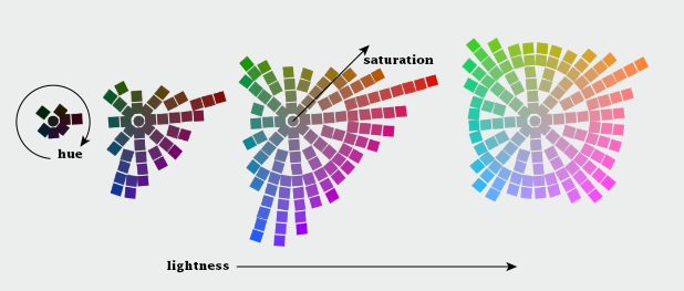
Read Full Post


The purpose of data visualization—any data visualization—is to illuminate data. To show patterns and relationships that are otherwise hidden in an impenetrable mass of numbers.
NASA astronaut Karen Nyberg took this photograph of moonrise and sunrise over Earth’s limb on August 4, 2013. In a tweet, Nyberg noted that she also saw Jupiter and Mercury as she looked out from the International Space Station, but the glare of the Sun’s light hid them in her photo. When astronomer and Slate blogger Phil Plait […]
Periodically, Earth Observatory answers reader questions on this blog. Here’s a recent note from Manny J of New York City: “I recall that starting on May 15, 2013, the cold did not leave [New York]. In fact, it still felt like winter because it refused to warm up. Then came June 2013, with the sky overcast […]
Comedian Stephen Wright has a one-liner that he used to deploy in his stand-up routines: “Every so often, I like to stick my head out of the window, look up, and smile for a satellite picture.” This weekend, the entire planet is being encouraged to take that chance at least twice. The Cassini spacecraft — […]
Each month, Earth Observatory offers up a puzzling satellite image here on Earth Matters. The eighteenth puzzler is above. Your challenge is to use the comments section to tell us what part of the world we are looking at, when the image was acquired, and why the scene is interesting. How to answer. Your answer […]
The following is an excerpt from a story by Maria-Jose Vinas, NASA’s Earth Science News Team Defying 30 mph gusts and temperatures down to minus 22°F, NASA’s new polar rover, GROVER, recently demonstrated in Greenland that it could operate completely autonomously in one of Earth’s harshest environments. The solar-powered robot, developed by students, was able […]
The following is an excerpt from a story by Alan Buis, NASA’s Jet Propulsion Laboratory… The curtain has come down on a superstar of satellite oceanography that played the “Great Blue Way” of the world’s ocean for 11.5 years. The joint NASA and Centre National d’Etudes Spatiales (CNES) Jason-1 ocean altimetry satellite was decommissioned on […]
Somehow, a recent conversation on Twitter about tweet density led to a mention of the installation of variable highway lighting in the Netherlands, by way of the 2012 NASA/NOAA city lights map. Which made me wonder—would we be able to see the effects of the new lighting from space? After all, the day night band […]
On June 19, 2013, the U.S. Geological Survey officially decommissioned Landsat 5 after an astonishing 29 years of operation. The satellite’s longevity was recognized by the Guinness Book of World Records, which dubbed Landsat 5 as the longest-operating Earth observation satellite. I recently listened to Dr. Steve Covington — the flight systems manager for Landsat […]