


![Request for Information – Potential [Placeholder for Prize]](https://assets.science.nasa.gov/dynamicimage/assets/science/psd/solar/2023/09/s/solarsystem_0.jpg?w=1024)


CSDA Vendor - MDA Space
NASA's Commercial Satellite Data Acquisition (CSDA) program has acquired commercial datasets from MDA Space for scientific purposes.
MDA Space operates the RADARSAT-2 synthetic aperture radar (SAR) satellite, which offers 20 different beam modes and acquires data that can be used to monitor surface dynamics, the cryosphere, ecosystems, ocean science, natural hazards, and disasters. Launched in 2007 following the success of RADARSAT-1, RADARSAT-2 is a unique collaboration between MDA Space and the Canadian Space Agency, which partially funds the mission.
Obtaining Data
- To request access to CSDA-distributed data, complete the CSDA Authorization form. The CSDA team will verify if the user is authorized for data access.
Copyright
For all RADARSAT-2 images, in any format, the following copyright must be used:
“RADARSAT-2 Data and Products © MDA Geospatial Services, Inc. (year) – All Right Reserved. RADARSAT is an official trademark of the Canadian Space Agency”
*Note the year of image publication versus the year of image acquisition will suffice. *
CSDA Acknowledgement
To help CSDA identify your publications, we request that you include the following acknowledgment when publishing work created using these data:
“This work utilized data made available through the NASA Commercial Satellite Data Acquisition (CSDA) Program.” Authorized users should send CSDA a courtesy copy of any publications that include CSDA-distributed data.
Evaluations
The MDA Space RADARSAT-2 Synthetic Aperture Radar (SAR) Quality Assessment Report is now available.
RADARSAT-2 SAR Characteristics and Image Modes
Characteristics
| Launch | December 14, 2007 |
| Wavelength | C-band (5.6 cm) |
| Nominal altitude | 800 km |
| Resolution (m) | Variable (see table below) Nominal 1 to 100 |
| Image size (Range x Azimuth) (km) | Variable (see table below) Nominal 18 x 8 (min) to 500 x 500 (max) |
| Orbit | Sun-synchronous with 98.6° inclination Dawn-dusk 6 AM/6 PM descending/ascending node |
| Orbit tube | Maintained within ±150 m |
| Exact repeat | 24 days |
| Revisit | Variable: Equatorial latitudes, nominally 2-3 days; Polar latitudes, at least daily |
| Polarization | Single polarized: (HH, HV, VH, VV) Dual polarized: (HH + HV) or (VH + VV) Quad polarized (phase preserving): (HH, HV, VH, VV) |
| Imaging modes (20) | 1 Spotlight; 15 Stripmap, and 4 ScanSAR |
| Image products | Spotlight and Stripmap: slant range single-look complex ground range detected geocoded detected ScanSAR: ground range detected only |
RADARSAT-2 SAR Image Modes
Nominal characteristics for detected products: SP = Single-pol, DP = Dual-Pol (HH+HV) or (VV+VH), QP = Quad-Pol (HH+HV+VH+VV), NESZ = Noise Equivalent Sigma Zero
| Image Mode | Resolution [Rng x Az] (m) | Scene Size [Rng x Az] (km) | Incidence Angle Range [deg] | No. Looks [Rng x Az] | Polarization | NESZ (dB) |
| Spotlight | 4.6 – 2.0 x 0.8 | 18 x 8 | 20 to 54 | 1 x 1 | SP | -16 |
| Ultra-Fine | 4.6 – 2.0 x 2.8 | 20 x 20 | 20 to 54 | 1 x 1 | SP | -22 |
| Wide Ultra-Fine | 3.3 – 2.1 x 2.8 | 50 x 50 | 29 to 50 | 1 x 1 | SP | 14 |
| Multi-Look Fine | 10.4 – 6.8 x 7.6 | 50 x 50 | 30 to 50 | 2 x 2 | SP | -16 |
| Wide Multi-Look Fine | 10.8 – 6.8 x 7.6 | 90 x 50 | 29 to 50 | 2 x 2 | SP | -13 |
| Extra-Fine | 8.4 – 4.1 x 4.6 | 125 x 125 | 22 to 49 | 1 x 1 | SP | -20 |
| Fine | 10.4 – 6.8 x 7.7 | 50 x 50 | 30 to 50 | 1 x 1 | SP/DP | -22 |
| Wide Fine | 14.9 – 7.3 x 7.7 | 150 x 150 | 20 to 45 | 1 x 1 | SP/DP | -20 |
| Standard | 26.8 – 17.3 x 24.7 | 100 x 100 | 20 to 52 | 1 x 4 | SP/DP | -26 |
| Wide | 40.0 – 19.2 x 24.7 | 150 x 150 | 20 to 45 | 1 x 4 | SP/DP | -24 |
| Extended High | 18.2 – 15.9 x 24.7 | 75 x 75 | 49 to 60 | 1 x 4 | HH only | -25 |
| Extended Low | 52.7 – 23.3 x 24.7 | 170 x 170 | 10 to 23 | 1 x 4 | HH only | -24 |
| Fine Quad-Pol | 16.5 – 6.8 x 7.6 | 25 x 25 | 18 to 49 | 1 x 1 | QP | -31 |
| Standard Quad-Pol | 28.6 – 17.7 x 7.6 | 25 x 25 | 18 to 49 | 1 x 1 | QP | -35 |
| Wide Fine Quad-Pol | 17.3–7.8 x 7.6 | 50 x 25 | 18 to 42 | 1 x 1 | QP | -24 |
| Wide Standard Quad-Pol | 30.0 –16.7 x 7.6 | 50 x 25 | 18 to 42 | 1 x 1 | QP | -26 |
| ScanSAR Narrow | 81–38 x 40-70 | 300 x 300 | 20 to 46 | 2 x 2 | SP/DP | -25 |
| ScanSAR Wide | 163–73 x 78-106 | 500 x 500 | 20 to 49 | 4 x 2 | SP/DP | -25 |
| Ocean Surveillance | 80-36 x 27-99 | 500 x 500 | 20 to 50 | 4 x 1 | SP/DP | -24 |
| Detection of Vessels | 33-23 x 19-77 | 450 x 500 | 35 to 56 | 5 x 1 | HH only | -20 |
Authorized Data Use and Users
Access to this data is governed by the CSDA End User License Agreements (EULAs). The minimum access level for data is the USG license. Depending on the specific data products provided, some or all data may also be available under higher-tier CSDA licenses, including USG‑Plus and Public licenses.
Under the applicable license tier, authorized users may include:
- U.S. Government federal employees
- State, local, territorial, and tribal government personnel
- U.S. Government contractors and subcontractors
- U.S. Government–funded researchers and academic partners
- Other users authorized under applicable CSDA license levels (USG, USG‑Plus, or Public)
All data use must comply with the terms of the EULA. All data requests must be reviewed and approved by NASA’s Commercial Satellite Data Acquisition (CSDA) program.
Learning Resources
For more information about the commercial data from MDA Space available through the CSDA program, see the MDA Space NASA CSDA Vendor Focus webinar.
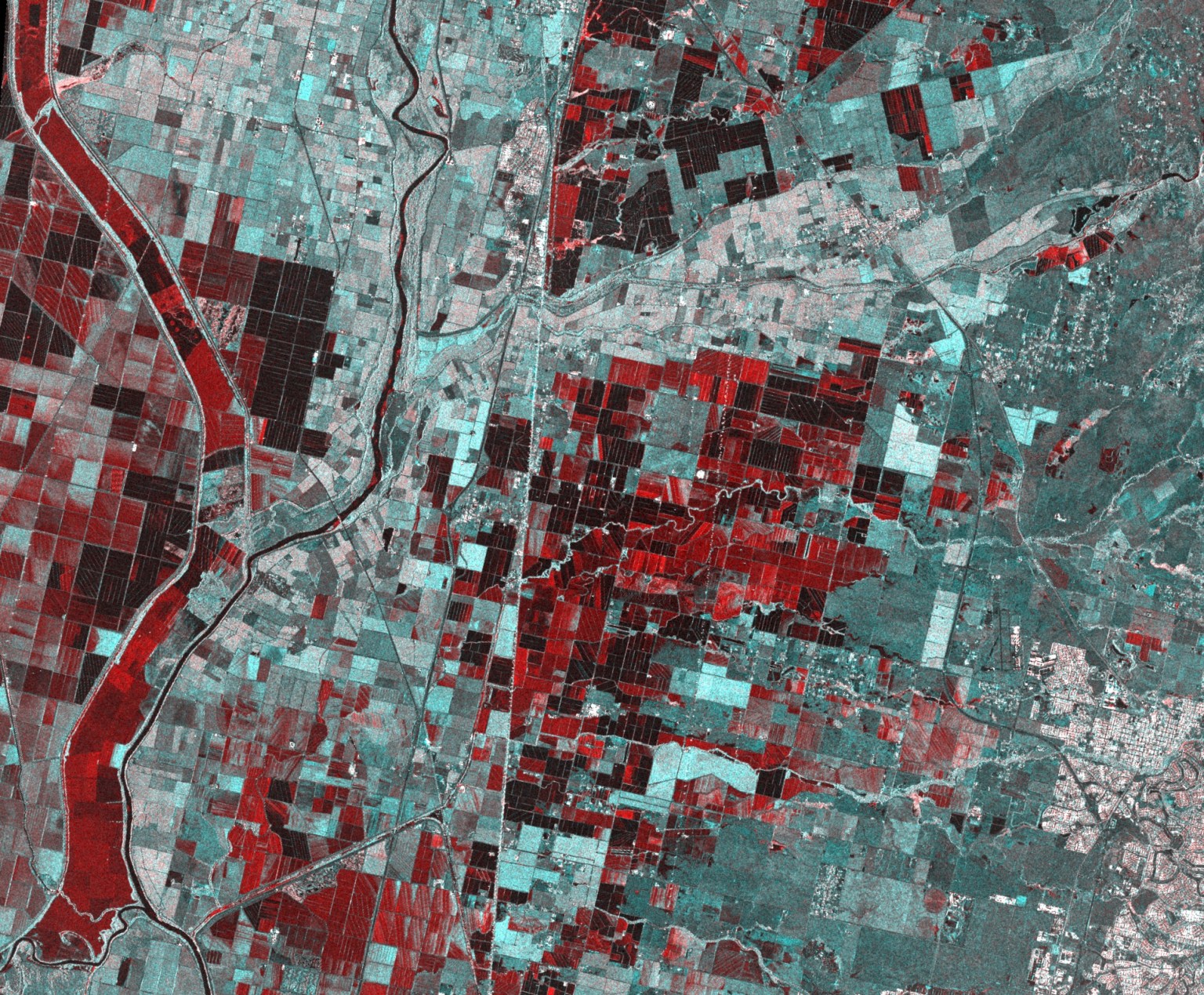
Image: Sacramento, California flood image was based on the use of 5 meter resolution RADARSAT-2 ExtraFine images acquired pre-flood (Nov 11, 2022) and post-flood (Jan 1, 2023). The flooded areas are depicted in red. RADARSAT-2 Data and Products © MDA Geospatial Services, Inc. (2022) - All Right Reserved. RADARSAT is an official trademark of the Canadian Space Agency