


![Request for Information – Potential [Placeholder for Prize]](https://assets.science.nasa.gov/dynamicimage/assets/science/missions/a-step/FFR_Earth_Background_20251120%20.png?w=1024)


CSDA Vendor - GHGSat
NASA's Commercial Satellite Data Acquisition (CSDA) program has acquired commercial datasets from GHGSat for scientific purposes.
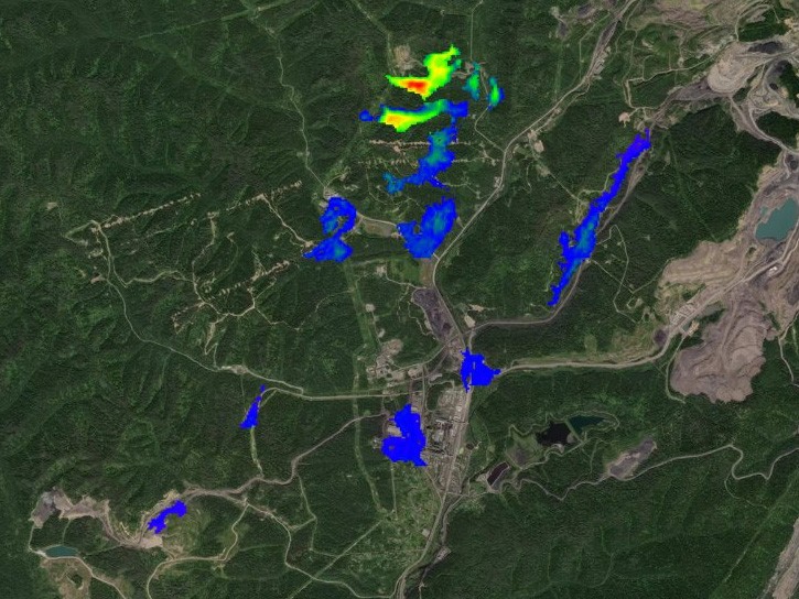
GHGSat specializes in high-resolution remote sensing of greenhouse gases from space. GHGSat has a constellation of small satellites that are capable of measuring methane emissions from point sources as small as landfills and individual oil and gas wells. GHGSat satellites typically have a spatial resolution of <30 m (>50 m for GHGSat-D) and the Field of View (FOV) of approximately 12 km x 12 km of these datasets allow gas plumes emitted from industrial sources to be captured and distinguished from the surrounding background concentrations, constituting a differential measurement. The reflectance and abundance products can be combined into a high readability "Concentration Map" for human interpretation. The abundance of datasets from multiple observations of a given site can be combined to form a monitoring product for semi-automatic detection of emitter activity or large changes in emission rates using pre-determined thresholds. Abundance datasets also allow emission rates to be estimated for individual sources. Plume dispersion is modeled using site information and weather data from global meteorological models or local weather stations and matched to the measured datasets.
Obtaining Data
- To request access to CSDA data offerings, complete the CSDA Authorization form. The CSDA team will verify if the user is authorized for data access.
- Search and download GHGSat data using the CSDA Satellite Data Explorer (SDX). An Earthdata Login is required.
Copyright
Data products and derivatives for imagery must contain the following copyright markings (YYYY is the year of the image acquisition):
- For data products: “© GHGSat Inc YYYY. All rights reserved.”
- For derivatives: “Includes copyrighted material of GHGSat. All rights reserved.”
- A joint copyright notice may be used as appropriate
CSDA Acknowledgment
To help CSDA identify your publications, we request that you include the following acknowledgment when publishing work created using these data:
"This work utilized data made available through the NASA Commercial Satellite Data Acquisition (CSDA) program." Authorized users should send CSDA a courtesy copy of any publications that include CSDA-provided data.
Evaluation
The GHGSat PI Evaluation Summary, Atmospheric Column Quality Assessment Report, and the Emission Quality Assessment Report are available for review.
Authorized Data Use and Users
Access to this data is governed by the CSDA End User License Agreements (EULAs). The minimum access level for data is the USG license. Depending on the specific data products provided, some or all data may also be available under higher-tier CSDA licenses, including USG‑Plus and Public licenses.
Under the applicable license tier, authorized users may include:
- U.S. Government federal employees
- State, local, territorial, and tribal government personnel
- U.S. Government contractors and subcontractors
- U.S. Government–funded researchers and academic partners
- Other users authorized under applicable CSDA license levels (USG, USG‑Plus, or Public)
All data use must comply with the terms of the EULA. All data requests must be reviewed and approved by NASA’s Commercial Satellite Data Acquisition (CSDA) program.
Learning Resources
For more information about the commercial data from GHGSat available through the CSDA program, see the GHGSat NASA CSDA Vendor Focus webinar.