




























Data Evaluation
NASA evaluates commercial data to ensure they meet the agency’s standards for scientific quality, accuracy, and usability.

Delivering Science-as-a-Service
NASA’s Commercial Satellite Data Acquisition (CSDA) program delivers “science as a service” by providing the Earth science community with operational, turnkey access to rigorously assessed commercial satellite data. Through CSDA, NASA acquires commercial Earth observation datasets, curates them within a stable, API‑driven delivery infrastructure with standardized metadata, and ensures that all datasets undergo independent quality assessment.
This model enables NASA researchers to rely on evaluated data products without needing to independently procure and evaluate commercial data, effectively transforming commercial data into a ready‑to‑use scientific service. By maintaining consistent evaluation frameworks, and offering repeatable acquisition processes, CSDA reduces barriers to commercial data adoption and accelerates scientific discovery across NASA’s Earth science portfolio.
NASA Approach - CSDA Process
As noted in the 2018 Decadal Survey, a document that captures the consensus within the scientific community on the most pressing and promising areas of research and directs NASA's strategic priorities and mission directives for the next decade, NASA must “ensure that commercial data meet the quality standards required for scientific analyses and operational applications, particularly in the area of climate observations for which accuracy, precision, and stability are critical to characterizing and understanding change.”
To meet that requirement, the CSDA program is rigorously evaluating commercial data for Earth science research and applications through its own comprehensive evaluation process. The key evaluation components of this process are:
- Accessibility of vendor supplied imagery and data
- Accuracy and completeness of metadata
- Quality of User Support Services
- Usefulness of data for advancing Earth system science research and applications
- Quality of vendor supplied imagery and/or data
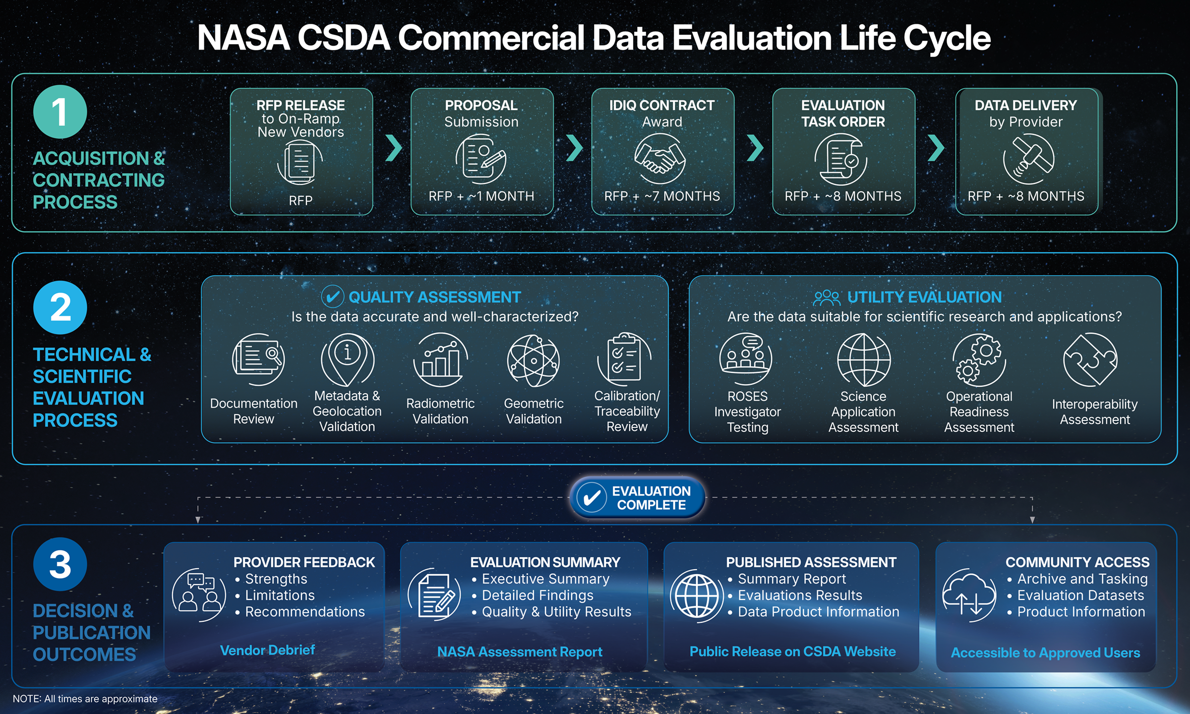
Commercial Data Provider
On-ramping and Evaluation
CSDA provides structured on-ramping opportunities for emerging commercial satellite data vendors, enabling NASA to continuously integrate innovative data sources as the private sector evolves. By leveraging these partnerships, NASA’s Earth Science Division (ESD) aims to accelerate scientific discovery and expand applications of Earth observation data for societal benefit.
CSDA’s rigorous and high-quality evaluation process relies on a select group of subject matter experts (SMEs) to assess the long-term scientific quality and utility of commercial remote sensing data. These experts play a strategic role in bridging scientific needs with commercial capabilities and advancing Earth science research and applications. This approach not only ensures NASA gains timely access to high-quality, mission-relevant commercial data, but also provides valuable feedback to private-sector providers, fostering innovation, improved data products, and alignment of industry capabilities with NASA’s evolving scientific needs.
Quality and Evaluation Framework
NASA evaluates commercial data to inform the user community of the quality of CSDA commercial data before broad scientific use and supports informed decision-making on which commercial datasets provide meaningful benefit to NASA research and applications investigations. In turn, these efforts:
- Benefit NASA research and applications through the expansion of access to novel Earth observation measurements not available through NASA-owned assets and enhancing temporal and spatial coverage of key Earth system variables
- Help fill observation gaps and increase resilience through diverse, multisource data
- Strengthen NASA open science principles by ensuring data are suitable for release and use within NASA's open-science ecosystem, enabling broad access for the research community and government partners, and promoting transparency and consistent standards across commercial data providers
- Enhance programmatic and strategic value by providing a structured, repeatable framework for assessing rapidly evolving commercial capabilities, reducing risk by identifying technical limitations before acquisition, helping NASA partner more effectively with US industry and leverage commercial innovations, and aligning investments with mission needs and maximizing return on data procurement
- Better position NASA for the future by supporting faster integration of emerging commercial measurement types, increasing the agency's agility as the commercial Earth observation market continues to expand, and ensuring NASA remains at the forefront of Earth science by combining government and commercial strengths
The ESA-NASA Joint EO Mission Quality Assessment Framework
The CSDA program has partnered with the European Space Agency (ESA), USGS, and NOAA to establish the Joint EO Mission Quality Assessment Framework that provides standardized, transparent, and repeatable data quality assessment processes and outputs to support mission selection, data integration and trusted use of EO data for science and applications.
The Joint NASA-ESA EO Mission Quality Assessment Framework provides guidelines for assessing the quality and suitability of candidate data under consideration for providing to each partner’s user community.
The key elements of this framework include:
- Domain-specific guidelines tailored to EO data types
- Optical
- Synthetic Aperture Radar (SAR)
- Digital Elevation Models (DEMs)
- Atmospheric Composition
- Other
- Comprehensive Assessment of data quality, calibration, validation, documentation, and maturity
- Operational Use in ESA Copernicus Contributing Missions Scheme
- Sustained procurement for the NASA CSDA U.S. government user community
The result is a proven approach for ensuring data suitability for integration and operational use.
International Collaboration
The ESA-NASA Joint EO Mission Quality Assessment Framework has developed through strong partnerships between international forums and working groups, including the U.S. Joint Agency Commercial Imagery Evaluation (JACIE) and the ESA Very High-resolution Radar & Optical Data Assessment (VH-RODA).
Milestones:
- 2024: Official ESA – NASA signature of SAR domain guidelines
- 2026: Official ESA – NASA – USGS signature of Optical domain guidelines
Additional domains in progress:
DEM ● Atmospheric Composition ● Others
Unified Framework Goals:
- Maintain an official, transparent, and public framework for data quality assessment of candidate missions
- Serve TPM (ESA) and CSDA (NASA) programs
- Enable interoperability and compatibility across missions
- Support Copernicus Contributing Missions assessments
The Joint Core Output Cal/Val Maturity Matrix serves as a common reference for partner agencies that enables:
- Consistent data evaluation
- Cross-Mission Comparison
- Decision Support for Integration
- Transparency & Trust
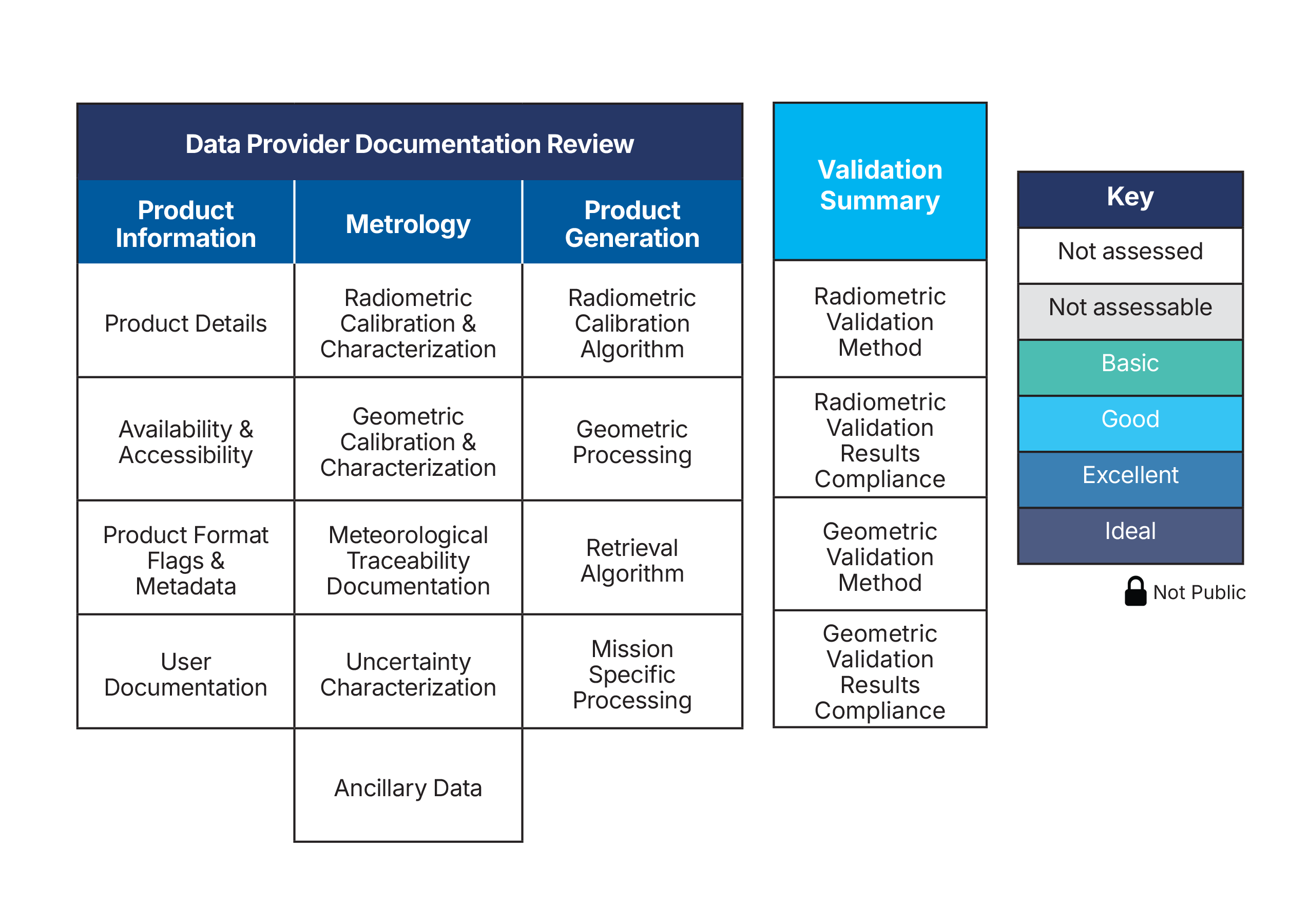
(Note: On completion of the assessment, the matrix is filled in with the color/grades shown in the key.)
The key objective of ESA-NASA Joint EO Mission Quality Assessment Framework is to take full advantage of the increased range of available data from non-publicly operated missions and to perform an early data assessment for various missions. These fall into a number of instrument domains including optical and synthetic aperture radar.
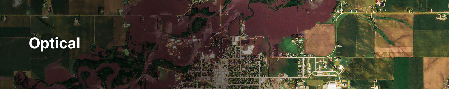
The Joint ESA-NASA and USGS Earth Observation Mission Quality Assessment Framework – Optical Guidelines were released on April 26, 2026, and provide specific guidelines for the mission quality assessment of optical sensors as part of the implementation of the generic Earth Observation (EO) mission quality assessment for the optical domain.
This document summarizes the goals of the Joint Earth Observation Mission Quality Assessment Framework, reviews how optical mission data quality is demonstrated through documentation, outlines guidelines for verifying that a mission’s data quality aligns with stated sensor performance, and provides appendices containing information on common radiometric and geometric data quality assessment practices.

The Joint ESA-NASA and USGS Earth Observation Mission Quality Assessment Framework – Synthetic Aperture Radar (SAR) Guidelines were released on June 9, 2024, and provide specific guidelines for the quality assessment of SAR sensor data, as part of the implementation of the generic EO mission quality assessment for this domain.
This document summarizes the SAR data quality assessment framework, provides the approach for assessing SAR mission data quality as evidenced by its documentation, and offers guidelines for evaluating whether the mission data quality is consistent with the stated performance of the sensor.