




























CSDA Vendor - GeoOptics
NASA's Commercial Satellite Data Acquisition (CSDA) program has acquired commercial datasets from GeoOptics.
GeoOptics, Inc. operated the Community Initiative for Cellular Earth Remote Observation (CICERO) constellation of Earth observing nanosatellites from late 2018 to January 2022, provideding radio occultation data products from their Global Navigation Satellite Systems (GNSS) Radio Occultation (GNSS-RO) receivers.
Obtaining Data
To request access to CSDA-distributed data, complete the CSDA Authorization form. The CSDA team will verify if the user is authorized for data access.
Search and download GeoOptics data using the CSDA Satellite Data Explorer (SDX). An Earthdata Login is required.
Copyright
Data products and derivatives must contain the following copyright markings (where YYYY is the year of the image acquisition):
- For GeoOptics, Inc data: “© GeoOptics, Inc., YYYY. All Rights Reserved.”
- For derivatives: "Includes copyrighted material of GeoOptics, Inc., All Rights Reserved.”
- A joint copyright notice may be used as appropriate
CSDA Acknowledgment
To help CSDA identify your publications, we request that you include the following acknowledgment when publishing work created using these data:
"This work utilized data made available through the NASA Commercial Satellite Data Acquisition (CSDA) program." Authorized users should send CSDA a courtesy copy of any publications that include CSDA-provided data.
Evaluation
Details of the CSDA assessment efforts can be found in the GeoOptics Principal Investigator Evaluation Summary and the GeoOptics Radio Occultation Data Quality Assessment Report.
GeoOptics Commercial Data
CSDA acquired data from GeoOptics from January 2020 to April 2021. Below are the products acquired by CSDA that are available to authorized users.
| Processing Levels | Data Product |
| Level 0* | Raw open loop/close-loop phase & attitude measurements |
| Level 1a | Antenna Parameters (podObs) |
| LEO attitude data (leoAtt) | |
| RO datasets, high rate 50 Hz (opnGns) | |
| Level 1b | LEO POD data (cicPOD, orbits and clock biases) |
| Atmospheric excess phase (cicPrf, cicPOD) | |
| Signal-to-Noise Ratio (opnGns, cicPOD) | |
| Level 2 (Atmospheric Data) | Bending angle, refractivity, dry pressure and dry temperature (cicPrf) |
| Water vapor, temperature and pressure (1DVar) | |
| BUFR data | |
| Level 2 (Ionospheric Data) | occTec (TEC at a negative elevation angle from POD antenna) |
| podTec (TEC at a positive elevation angle from POD antenna) |
Authorized Data Use and Users
Access to this data is governed by the CSDA End User License Agreements (EULAs). The minimum access level for data is the USG license. Depending on the specific data products provided, some or all data may also be available under higher-tier CSDA licenses, including USG‑Plus and Public licenses.
Under the applicable license tier, authorized users may include:
- U.S. Government federal employees
- State, local, territorial, and tribal government personnel
- U.S. Government contractors and subcontractors
- U.S. Government–funded researchers and academic partners
- Other users authorized under applicable CSDA license levels (USG, USG‑Plus, or Public)
All data use must comply with the terms of the EULA. All data requests must be reviewed and approved by NASA’s Commercial Satellite Data Acquisition (CSDA) program.
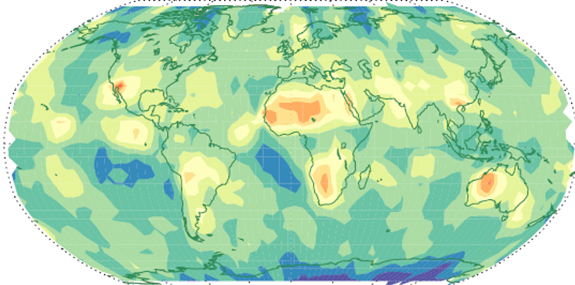
Top Banner Image: Monthly averaged mean Planetary Boundary Height top height in October obtained from GeoOptics RO data on a 10°´5° grid. A 3-point smoothing has been applied to smooth the features. Credit: Zhen Zeng, Principal Investigator, COSMIC Program Office, UCAR; Collaborators: Sergey Sokolovskiy, Richard Anthes, Jan‑Peter Weiss