


CSDA
Commercial Satellite Data Acquisition Program

About the CSDA Program
NASA's Earth Science Division (ESD) established the Commercial Satellite Data Acquisition (CSDA) program to explore the potential of commercial satellite data in advancing the agency's Earth science research and application objectives. The program aims to identify, assess, and acquire data from commercial providers, which may offer a cost-effective means of supplementing Earth observations collected by NASA, other U.S. Government agencies, and international collaborators.
CSDA Mission:
- Execute a cost-effective way to augment and complement the suite of Earth observations captured by NASA and its partners by identifying, evaluating, and acquiring commercial satellite data.
Strategic Objectives:
- Enable continuous and repeatable processes to on-ramp commercial data vendors and evaluate data for their potential to advance NASA's Earth science research and applications activities.
- Enable the sustained use of purchased data for broader use and dissemination by the Earth scientific community.
- Ensure long-term data preservation through the establishment of data management processes and systems to support rapid evaluation, access, and distribution of purchased data and long-term access for scientific reproducibility.
- Coordinate with other U.S. Government agencies and international partners on the evaluation and scientific use of commercial data.
Why Does NASA Buy Commercial Data?
NASA’s fleet delivers global, first-of-its kind observations with open, validated data that forms the backbone of its Earth-system science and applications missions. Commercial data enhances these efforts by offering:
- Higher resolution & more frequent observations
- Taskable observations
- Flexible, real-time, niche data services
- Cost-effective options for users
Enhancing NASA datasets with complementary or unique measurements from commercial data providers bolsters NASA and U.S. Government satellite capabilities and expands their capacity to monitor, predict, and respond to Earth’s dynamic systems.
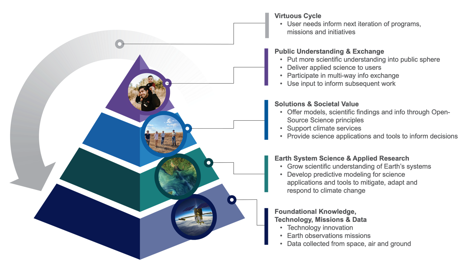
Supporting Earth Science to Action
NASA’s Earth Science to Action strategy is designed to help decision-makers use Earth observation data faster, accelerating and advancing the impact of NASA Earth science for the benefit of all humankind. To achieve this, NASA endeavors to work across agencies and across sectors to bring the diverse communities of Earth science together to generate the data and information users need to develop strategies for assessing, adapting, mitigating, and responding to the risks and impacts of global change.
Commercial satellite data supports this effort, and several real-world examples have already demonstrated, these data can be integrated with data from NASA Earth observation missions to map wildfires, monitor soil moisture and subsidence, develop on-demand flood mapping tools, and more.
Partnerships
NASA’s CSDA program works closely with other U.S. Government agencies, including the Civil Applications Committee, National Geospatial-Intelligence Agency, National Oceanic and Atmospheric Administration, National Reconnaissance Office, U.S. Department of Agriculture, U.S. Geological Survey, United States Space Force, and the United States Air Force, as well as interagency efforts, such as the Joint Agency Commercial Imagery Evaluation (JACIE), to identify data requirements and needs, coordinate commercial data purchases, align data acquisitions, and share data evaluation processes.
In addition, the CSDA program collaborates with international partners to develop guidelines, data evaluations, and programmatic and technological processes. For example, CSDA and the European Space Agency (ESA) developed the Joint Earth Observation Mission Quality Assessment Framework to ensure that decisions on acquisition of commercial data can be made with confidence. This initiative produced a set of guidelines to assess the quality of data from commercial sources and further strengthened the partnership between ESA and NASA.
Frequently Asked Questions
NASA-acquired commercial satellite data distributed by CSDA have guidelines for their use. For general information about who is considered a NASA-funded or U.S. Government-funded researcher, commercial data available for download, the approval process for access to commercial data, and much more, please see the extensive CSDA list of Frequently Asked Questions (FAQs).
Connect with Us
Contact the CSDA Program via email
Join the NASA CSDA Program mailing list to get our latest news in your inbox. To subscribe, email us at csda-program-news-join@lists.nasa.gov.
You can also subscribe to our quarterly newsletter, the CSDA Orbit