




























CSDA Vendor - Umbra
NASA's Commercial Satellite Data Acquisition (CSDA) program has acquired commercial datasets from Umbra.
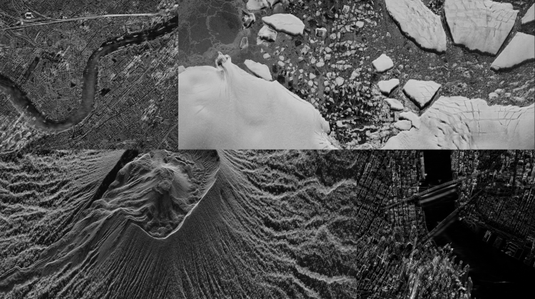
Umbra designs, manufactures, and operates a commercial Synthetic Aperture Radar (SAR) satellite constellation, providing high-resolution Spotlight and Scan imagery with resolutions as fine as 25 centimeters. Umbra’s proprietary satellite and antenna architecture is designed to provide high antenna gain and strong signal-to-noise performance, enabling very high-resolution SAR imaging while maintaining radiometric quality and geolocation accuracy suitable for scientific applications. Umbra’s SAR data is particularly well suited for applications requiring all-weather, day-night imaging capability, including cryosphere and glacier monitoring, flood and disaster response, geohazard assessment, coastal change detection, and land-cover change analysis.
Obtaining Data
- To request access to CSDA-distributed data, complete the CSDA Authorization form. The CSDA team will verify if the user is authorized for data access.
- Search and download Umbra data using the CSDA Satellite Data Explorer (SDX). An Earthdata Login is required
Copyright
Data products and derivatives must contain the following copyright markings (where YYYY is the year of the image acquisition):
- For Umbra data: “© Umbra Lab Inc., YYYY. All Rights Reserved.”
- For derivatives: "Includes copyrighted material of Umbra Lab Inc., All Rights Reserved.”
- A joint copyright notice may be used as appropriate
CSDA Acknowledgment
To help CSDA identify your publications, we request that you include the following acknowledgment when publishing work created using these data:
"This work utilized data made available through the NASA Commercial Satellite Data Acquisition (CSDA) Program." Authorized users should send CSDA a courtesy copy of any publications that include CSDA-distributed data.
Evaluation
The Umbra SAR PI Summary and Umbra SAR Quality Assessment reports are available online.
Umbra Commercial Data Available to Authorized CSDA Users
| Product | Technical Specifications |
| Spotlight | • Standard scene size coverage 5 km x 5 km • Varying spatial resolutions and looks count: ◦ 0.25 m spatial resolution, 1-2x looks ◦ 0.35 m spatial resolution, 1-3x looks ◦ 0.50 m spatial resolution, 1-4x, 8x, looks ◦ 1.0 m spatial resolution, 1-4x, 8x, 10x looks ◦ Single polarization (VV or HH) ◦ Squint angles up to 45 degrees off broadside ◦ Extended and long dwell options available upon request. |
| Scan | • Varying spatial resolutions and scene sizes: ◦ 2.00 m spatial resolution, 25 km to 100 km swath length ◦ 1.00 m spatial resolution, 25 km to 75 km swath length ◦ 0.50 m spatial resolution, 25 km to 50 km ◦ All scenes are 8 km wide ◦ Single polarization (VV or HH) ◦ Squint angles up to 60 degrees off broadside. |
| Product Delivery Formats | • CPHD – Compensated Phase History Data • SICD – Sensor Independent Complex Data • SIDD – Sensor Independent Derived Data • CSI SIDD – Sensor Independent Derived with Color Sub- Aperture Image • GEC GeoTIFF – Geo-Ellipsoid Corrected • CSI GeoTIFF – GEC GeoTIFF with Color Sub-Aperture Image |
Authorized Data Use and Users
Access to this data is governed by the CSDA End User License Agreements (EULAs). The minimum access level for data is the USG license. Depending on the specific data products provided, some or all data may also be available under higher-tier CSDA licenses, including USG‑Plus and Public licenses.
Under the applicable license tier, authorized users may include:
- U.S. Government federal employees
- State, local, territorial, and tribal government personnel
- U.S. Government contractors and subcontractors
- U.S. Government–funded researchers and academic partners
- Other users authorized under applicable CSDA license levels (USG, USG‑Plus, or Public)
All data use must comply with the terms of the EULA. All data requests must be reviewed and approved by NASA’s Commercial Satellite Data Acquisition (CSDA) program.
Learning Resources
For more information about the commercial data from Umbra available through the CSDA program, see the Umbra NASA CSDA Vendor Focus webinar.
Documentation
Top Banner Image: A mosaic of four SAR images collected by Umbra satellites shown in black-and-white. The top left image shows London, as the River Thames flows between the cityscapes. The top right image is from the Antarctic- pieces of ice are visible in this scene. The bottom left image is a high-resolution SAR image of the active volcano, Mount Ibu, in Indonesia. The bottom right image shows New York City with the Brooklyn and Manhattan bridge spanning across the East River waterfront. Image Credit: Umbra