


CSDA Vendor - Airbus
NASA's Commercial Satellite Data Acquisition (CSDA) program has acquired commercial datasets from Airbus for scientific purposes.
Airbus provides both optical and synthetic aperture radar (SAR) Earth observation products. Optical imagery is acquired with the Pléiades Neo, Pléiades and SPOT satellites, while SAR data is collected with the TerraSAR-X, TanDEM-X, and PAZ X-band radar satellites. Unlike optical imagery, SAR data is captured regardless of cloud cover and weather conditions. Airbus imagery delivers high temporal and spatial resolution and supports the generation of highly precise elevation information for nearly any point on Earth. The products support a wide range of Earth science application, including monitoring drift ice in the absence of daylight, detecting surface movement in oil and gas fields, and identifying objects in remote areas.
Obtaining Data
- To request access to CSDA-distributed data, complete the CSDA Authorization form. The CSDA team will verify if the user is authorized for data access.
- Search and download Airbus data using the CSDA Satellite Data Explorer (SDX). An Earthdata Login is required.
Copyright
Data products and derivatives for Airbus products must contain the appropriate copyright markings (YYYY is the year of data acquisition). A joint copyright notice may be used as appropriate.
| Airbus Product | Credit Attribution |
| Radar Products |
| Radar Constellation data of TerraSAR-X and/or TanDEM-X satellite origin | “© DLR e.V. <YYYY>, Distribution by Airbus Defence and Space GmbH” |
| Radar Constellation data of PAZ satellite origin | “PAZ satellite image © Hisdesat Servicios Estratégicos S.A., <YYYY>” |
| WorldDEMÔ elevation products SAR GCPs CoSSC data | “© DLR e.V. <YYYY>, and © Airbus Defence and Space GmbH” |
| Optical Products |
| SPOT 6 and 7 imagery Elevation 4 SRP products | “© Airbus DS <YYYY>” |
| Pléiades imagery Elevation 1 | “© CNES <YYYY>, Distribution Airbus DS” |
| Pléiades Neo imagery (Including HD15) Elevation 0.5 | “© Airbus DS <YYYY>” |
CSDA Acknowledgment
To help CSDA identify your publications, we request that you include the following acknowledgment when publishing work created using these data:
"This work utilized data made available through the NASA Commercial Satellite Data Acquisition (CSDA) program."Authorized users should send CSDA a courtesy copy of any publications that include CSDA-distributed data.
Evaluation
Airbus SAR Evaluation Report and Quality Assessment Summary
Research Using Airbus Data
Airbus CSDA Publications in Zotero
Airbus Commercial Data
| Optical Constellation Details |
| Attribute | Value |
|---|---|
| Launched | 2012 & 2014: SPOT 6 & 7 2011 & 2012: Pléiades 1A & 1B 2021: Pléiades Neo 3 & 4 |
| Resolution (Pan) | 1.5m: SPOT 6 & 7 0.5m: Pléiades 1A & 1B 0.3m: Pléiades Neo 3 & 4 |
| Bands | SPOT & Pléiades: 4 bands, plus Panchromatic Pléiades Neo: 6 bands, plus Panchromatic |
| Orbit | Sun-synchronous |
| Revisit frequency | One to two times daily, for any location on Earth |
| Optical Constellation Imagery Details |
| Pléiades Neo | Pléiades | SPOT | |
| Active Satellites | 2 | 2 | 1 |
| Resolution | Panchromatic: 0.3m Multispectral: 1.2m | Panchromatic: 0.5m Multispectral: 2m | Panchromatic: 1.5m Multispectral: 6m |
| Global Revisit | Daily | Daily | 1 to 3 days |
| Orbit | Sun-synchronous | Sun-synchronous | Sun-synchronous |
| Archive (km2) | >800,000,000 | >2,400,000,000 | >16,200,000,000 |
| Imaging Modes | Mono, Stereo, Tri-stereo | Mono, Stereo, Tri-stereo | Mono, Stereo, Tri-stereo |
| Image Depth | 8 or 12 bits | 8 or 12 bits | 8 or 12 bits |
| Spectral Bands | Pan: 450-800 Deep Blue: 400-450 Blue: 450-520 Green: 530-590 Red: 620-690 Red Edge: 700-750 NIR: 770-880 | Pan: 470-830 Blue: 430-550 Green: 500-620 Red: 590-710 NIR: 740-940 | Pan: 455-744 Blue: 454-519 Green: 527-587 Red: 624-694 NIR: 756-880 |
| Available Products | 30cm imagery Pan 0.3m (1 band) Pansharpened 0.3m (3, 4 or 6 bands) Multispectral 1.2m (4 or 6 bands) Bundle: Pan 0.3m + MS 1.2m (4 or 6 bands) HD15 imagery Pansharpened 0.15m (3 bands) Bundle: Pan 0.15m + MS 0.6m (4 bands) | Pan 0.5m (1 band) Pansharpened 0.5m (3 or 4 bands) Multispectral 2m (4 bands) Bundle: Pan 0.5m + MS 2m (4 bands) | Pan 1.5m (1 band) Pansharpened 1.5m (3 or 4 bands) Multispectral 6m (4 bands) Bundle: Pan 1.5m + MS 6m (4 bands) |
| SAR Constellation Details |
| Attribute | Value |
| Launched | 2007: TerraSAR-X 2010: TanDEM-X 2018: PAZ |
| Orbit | Sun-synchronous |
| Radar revisit frequency | One to two times daily, for any location on Earth |
| Interferometry repeat-cycle | Every 4, 7 and 11 days, for any location on Earth |
| Polarization | Single, dual - depending on imaging mode |
| Archive | >680,000 images |
| SAR Imaging Modes |
| Acquisition Mode | Scene Size (Width x Length) | Resolution |
| Staring SpotLight (ST) | 4 x 3.7 km | up to 0.25m |
| High-Resolution SpotLight (HS) | up to 10 x 5 km | up to 1m |
| SpotLight (SL) | 10 x 10 km | up to 2m |
| StripMap (SM) | 30 x 50 km | up to 3m |
| ScanSAR (SC) | 100 x 150 km | up to 18.5m |
| Wide ScanSAR (WSC) | up to 270 x 200 km | up to 40m |
| CoSSC (Co-registered Slant Range Complex) is a global, specialized, high-level SAR data product derived from the TerraSAR-X (TSX) and TanDEM-X (TDX) missions, designed specifically for interferometric processing. Please contact your NASA CSDA representative for more information on obtaining CoSSC data. |
| Airbus Digital Elevation Models (DEMs) |
| Pléiades Neo | Pléiades | TerraSAR-X/TanDEM-X |
| Product | Elevation0.5 | Elevation4 | Elevation1 | WorldDEM | WorldDEM Neo |
| Resolution | 0.5m | 4m | 1m | 12m | 5m |
| Accuracy (abs. vert. LE90) | 1m | 1.5m | 2m | 2.5m | <2.5m |
| Product | DSM & DTM | DSM & DTM | DSM & DTM | DSM & DTM | DSM & DTM |
| Availability | On demand | On demand | On demand | On demand | Off-the-shelf |
| Currency | Fresh data | Fresh data | Fresh data | 2011-2015 | 2017-2021 |
| Coverage | Local to regional | Local to regional | Local to regional | Global | Global |
Airbus Ground Control Products
Airbus’ Spatial References Points (SRPs) are a global Ground Control Point (GCP) reference layer, derived from SPOT 6 and 7 imagery. Each SRP point consists of a set of SPOT image chips, with a highly-accurate 3D measurement at their center. The primary use of SRPs is to register any kind of optical image, which might have poor native location accuracy.
In addition, Airbus generates highly-accurate Ground Control Points (GCPs) from the Radar constellation satellites. GCPs represent a specific geolocation of an object on the Earth’s surface, with geolocation accuracies up to 10cm in horizontal (2D) and vertical (3D) directions. These measured objects are mainly infrastructure features such as lightning poles, traffic signs, fences, and other notable elements on buildings.
Please contact the CSDA program for more information on obtaining SRPs or GCPs.
Authorized Data Use and Users
Access to this data is governed by the CSDA End User License Agreements (EULAs). The minimum access level for data is the USG license. Depending on the specific data products provided, some or all data may also be available under higher-tier CSDA licenses, including USG‑Plus and Public licenses.
Under the applicable license tier, authorized users may include:
- U.S. Government federal employees
- State, local, territorial, and tribal government personnel
- U.S. Government contractors and subcontractors
- U.S. Government–funded researchers and academic partners
- Other users authorized under applicable CSDA license levels (USG, USG‑Plus, or Public)
All data use must comply with the terms of the EULA. All data requests must be reviewed and approved by NASA’s Commercial Satellite Data Acquisition (CSDA) program.
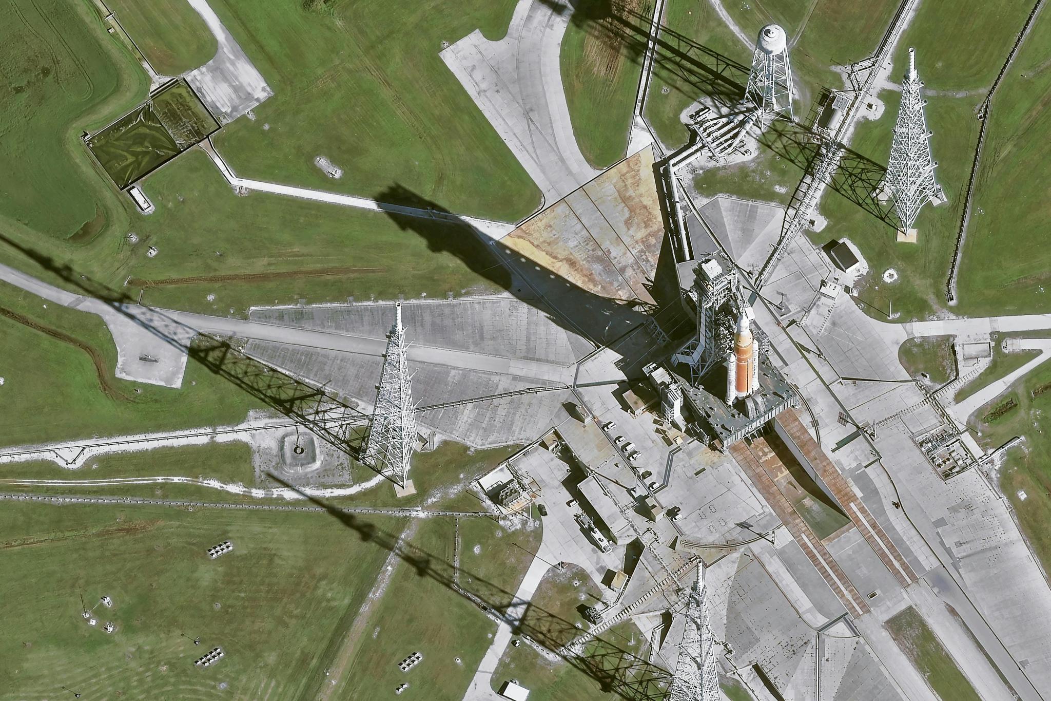
Image: Airbus’ Pléiades Neo satellite imaged Artemis II on the launchpad. Acquisition date January 19, 2026: Pléiades Neo HD15 © Airbus DS 2026