











![Request for Information – Potential [Placeholder for Prize]](https://assets.science.nasa.gov/dynamicimage/assets/science/psd/solar/2023/09/s/solarsystem_0.jpg?w=1024)







CSDA Vendor - Vantor
NASA has acquired commercial datasets from Vantor (formerly Maxar) for scientific purposes.
Vantor, Inc. (formerly Maxar Intelligence) offers very high resolution multispectral, 3D terrain and elevation data, and dynamic 2D basemaps through their satellite constellation, including: WorldView-1, WorldView-2, WorldView-3, WorldView-4, GeoEye-1, QuickBird, and IKONOS.
Obtaining Data
- To request access to CSDA-distributed data, complete the CSDA Authorization form. The CSDA team will verify if the user is authorized for data access.
- Search and download Vantor data using the CSDA Satellite Data Explorer (SDX). An Earthdata Login is required
- A large subset of Vantor’s data holdings are available for download using NASA Earthdata Search.
Copyright
Data products and derivatives for imagery must contain copyright markings as specified below, where YYYY is the year of the image acquisition.
For all instruments except WorldView-4 and IKONOS: ©YYYY, Vantor, USG Plus
For IKONOS: ©YYYY, Vantor, NextView
For Worldview-4:
- Data products: "© Vantor, Inc. YYYY. All rights reserved."
- Derivatives: "Includes copyrighted material of Vantor, Inc. All rights reserved."
CSDA Acknowledgment
To help CSDA identify your publications, we request that you include the following acknowledgment when publishing work created using these data:
"This work utilized data made available through the NASA Commercial Satellite Data Acquisition (CSDA) Program." Authorized users should send CSDA a courtesy copy of any publications that include CSDA-distributed data.
Evaluation
The Vantor Precision3D DEM Product Quality Assessment Report is now available.
Documentation
Algorithm Theoretical Basis Document for Vantor ACOMP Surface Reflectance Product
Research Using Vantor Data
Vantor CSDA Program Publications in Zotero (Formerly Maxar)
Vantor Commercial Data
View attributes and values for individual Vantor instruments.
Worldview-4 Specifications
| Attribute | Value |
|---|---|
| Orbit | Altitude: 617 km Type: Sun Synchronous, 10:30 a.m. descending Node Period: 97 min. |
| Life | Estimated service life: 10 to 12 years |
| Spacecraft size and aperture | Size: 5.3 m (17.7 ft) tall x 2.5 m (8 ft) across 7.9 m (26 ft) across deployed solar arrays Aperture: 1.1m |
| Sensor bands | Panchromatic: 450–800 nm 4 Multispectral: Red: 655–690 nm Green: 510–580 nm Blue: 450–510 nm Near-IR: 780–920 nm |
| Sensor resolution (or GSD, ground sample distance; off-nadir is geometric mean) | Panchromatic Nadir: 0.31 m 20° Off-Nadir: 0.34 m 56° Off-Nadir: 1.00 m Multispectral Nadir: 1.24 m 20° Off-Nadir: 1.38 m 56° Off-Nadir: 4.00 m |
| Dynamic range | 11-bits per pixel |
| Swath width | At nadir: 13.2 km |
| Attitude determination and control | Type: 3-axis Stabilized Actuators: Control Moment Gyros (CMGs) Sensors: Star trackers, precision IRU, GPS |
| Pointing accuracy and knowledge | Accuracy: 170 m at 40 off-nadir Knowledge: Supports geolocation accuracy below |
| Retargeting agility | Time to Slew 200 km: 10.6 sec |
| Onboard storage | 3200 Gb solid state with EDAC |
| Communications | Image and ancillary data: 800 Mbps X-band Housekeeping: 120 kbps real time, X-band Command: 64 kbps S-band |
| Max contiguous area collected in a single pass (30° off-nadir angle) | Mono: 66.5 km x 112 km (5 strips) Stereo: 26.6 km x 112 km (2 pairs) |
| Revisit frequency (at 40°N latitude) | 1 m GSD: < 1.0 day Total constellation > 4.5 accesses/day |
| Geolocation accuracy (CE90) | Predicted < 5 m CE90 without ground control |
| Capacity | 680,000 km2 per day |
Worldview-3 Specifications
| Attribute | Value |
|---|---|
| Orbit | Altitude: 617 km Type: Sun synchronous, 10:30 a.m. descending node Period: 97 min. |
| Life | Spec Mission Life: 7.25 years Estimated service life: 10 to 12 years |
| Spacecraft size, mass and power | Size: 5.7 m (18.7 ft) tall x 2.5 m (8 ft) across 7.1 m (23 ft) across deployed solar arrays Mass: 2800 kg (6200 lbs) Power: 3.1 kW solar array, 100 Ahr battery |
| Sensor Bands | Panchromatic: 450–800 nm |
| 8 Multispectral: Coastal: 397–454 nm Blue: 445–517 nm Blue: 445–517 nm Green: 507–586 nm Yellow: 580–629 nm Red: 626–696 nm Red Edge: 698–749 nm Near-IR1: 765–899 nm Near-IR2: 857–1039 nm | |
| 8 SWIR Bands: SWIR-1: 1184–1235 nm SWIR-2: 1546–1598 nm SWIR-3: 1636–1686 nm SWIR-4: 1702–1759 nm SWIR-5: 2137–2191 nm SWIR-6: 2174–2232 nm SWIR-7: 2228–2292 nm SWIR-8: 2285–2373 nm | |
| 12 CAVIS Bands: Desert Clouds: 405–420 nm Water-3: 930–965 nm Aerosol-1: 459–509 nm Green: 525–585 nm Aerosol-2: 635–685 nm Water-1: 845–885 nm Water-2: 897–927 nm NDVI-SWIR: 1220–1252 nm Cirrus: 1365–1405 nm Snow: 1620–1680 nm Aerosol-1: 2105–2245 nm Aerosol-2: 2105–2245 nm | |
| Sensor resolution (or GSD, Ground Sample Distance; off-nadir is geometric mean) | Panchromatic nadir: 0.31 m 20° off-nadir: 0.34 m Multispectral nadir: 1.24 m 20° off-nadir: 1.38 m SWIR nadir: 3.70 m 20° off-nadir: 4.10 m CAVIS nadir: 30.00 m |
| Dynamic range | 11-bits per pixel Pan and MS; 14-bits per pixel SWIR |
| Swath width | At nadir: 13.1 km |
| Attitude determination and control | Type: 3-axis Stabilized Actuators: Control Moment Gyros (CMGs) Sensors: Star trackers, precision IRU, GPS |
| Pointing accuracy and knowledge | Accuracy: <500 m at image start/stop Knowledge: Supports geolocation accuracy below |
| Retargeting agility | Time to Slew 200 km: 12 sec |
| Onboard storage | 2199 Gb solid state with EDAC |
| Communications | Image and Ancillary Data: 800 and 1200 Mbps X-band Housekeeping: 4, 16, 32, or 64 kbps real time, 524 kbps stored, X-band Command: 2 or 64 kbps S-band |
| Max contiguous area collected in a single pass (30° off-nadir angle) | Mono: 66.5 km x 112 km (5 strips) Stereo: 26.6 km x 112 km (2 pairs) |
| Revisit frequency | 1 m GSD: <1.0 day |
| (at 40°N Latitude) | 4.5 days at 20° off-nadir or less |
| Geolocation accuracy (CE90) | Predicted <3.5 m CE90 without ground control |
| Capacity | 680,000 km2 per day |
Worldview-2 Specifications
| Attribute | Value |
|---|---|
| Orbit | Altitude: 770 km Type: Sun synchronous, 10:30 a.m. descending node Period: 100 min. |
| Mission Life | 10-12 years, including all consumables and degradables (e.g., propellant) |
| Spacecraft Size, Mass and Power | 5.7 m (18.7 ft) tall x 2.5 m (8 ft) across 7.1 m (23 ft) across the deployed solar arrays 2615 kg (5765 lbs) 3.2 kW solar array, 100 Ahr battery |
| Sensor Bands | Panchromatic: 450–800 nm 8 Multispectral: Coastal: 400–450 nm Blue: 450–510 nm Green: 510–580 nm Yellow: 585–625 nm Red: 630–690 nm Red Edge: 705–745 nm Near-IR1: 770–895 nm Near-IR2: 860–1040 nm |
| Sensor Resolution | Panchromatic: 0.46 m GSD at nadir, 0.52 m GSD at 20° off-nadir Multispectral: 1.85 m GSD at nadir, 2.07 m GSD at 20° off-nadir |
| Dynamic Range | 11-bits per pixel |
| Swath Width | 16.4 km at nadir |
| Attitude Determination and Control | 3-axis stabilized Actuators: Control Moment Gyros (CMGs) Sensors: Star trackers, solid state IRU, GPS |
| Pointing Accuracy and Knowledge | Accuracy: < 500 m at image start and stop Knowledge: Supports geolocation accuracy below |
| Retargeting Agility | Time to Slew 200 km: 10 sec |
| Onboard Storage | 2199 Gb solid state with EDAC |
| Communications | Image and Ancillary Data: 800 Mbps X-band Housekeeping: 4, 16, or 32 kbps real-time, 524 kbps stored, X-band Command: 2 or 64 kbps S-band |
| Max Contiguous Area Collected in a Single Pass (30° off-nadir angle) | Mono: 138 x 112 km (8 strips) Stereo: 63 x 112 km (4 pairs) |
| Revisit Frequency (at 40°N Latitude) | 1.1 days at 1 m GSD or less 3.7 days at 20° off-nadir or less (0.52 m GSD) |
| Geolocation Accuracy (CE90) | Demonstrated < 3.5 m CE90 without ground control |
| Capacity | 1 million km2 per day |
Worldview-1 Specifications
| Attribute | Value |
|---|---|
| Orbit | Altitude: 496 km Type: Sun synchronous, 10:30 a.m. descending node Period: 95 min. Altitude: 496 km Type: Sun Synchronous. 1:30 p.m. descending node Period: 95 min. |
| Mission Life | 10-12 years, including all consumables and degradables (e.g., propellant) |
| Spacecraft Size, Mass and Power | 3.6 m (12 ft) tall x 2.5 m (8 ft) across 7.1 m (23 ft) across the deployed solar arrays 2290 kg (5038 lbs) 3.2 kW solar array, 100 Ahr battery |
| Sensor Bands | Panchromatic: 400–900 nm |
| Sensor Resolution | 50 cm Ground Sample Distance (GSD) at nadir 55 cm GSD at 20° off-nadir |
| Dynamic Range | 11-bits per pixel |
| Swath Width | 17.7 km at nadir |
| Attitude Determination and Control | 3-axis stabilized Actuators: Control Moment Gyros (CMGs) Sensors: Star trackers, solid state IRU, GPS |
| Pointing Accuracy and Knowledge | Accuracy: <500 m at image start and stop Knowledge: Supports geolocation accuracy below |
| Retargeting Agility | Time to Slew 200 km: 10 sec |
| Onboard Storage | 2199 Gb solid state with EDAC |
| Communications | Image and Ancillary Data: 800 Mbps X-band Housekeeping: 4, 16, or 32 kbps real-time, 524 kbps stored, X-band Command: 2 or 64 kbps S-band |
| Max Contiguous Area Collected in a Single Pass | Mono: 111 x 112 km (6 strips) |
| (30° off-nadir angle) | Stereo: 51 x 112 km (3 pairs) |
| Revisit Frequency | 1.7 days at 1 m GSD or less |
| (at 40°N Latitude) | 5.4 days at 20° off-nadir or less (0.55 m GSD) |
| Geolocation Accuracy (CE90) | Demonstrated <4.0 m CE90 without ground control |
| Capacity | 1.3 million km2 per day |
Ikonos Specifications
| Attribute | Value |
|---|---|
| Launch information | Launch Date: September 24, 1999 Launch Vehicle: Athena 2 Launch Site: Vandenberg Air Force Base, California |
| Mission life | 12+ years |
| Spacecraft size | 1.83 m × 1.57 m (hexagonal configuration) |
| Spatial resolution | Panchromatic: 0.82 m Multispectral: 3.2 m |
| Positional accuracy | 15 meter CE90 (specification) 9 meter CE90 (measured) |
| Swath width | 11.3 km |
| Off-nadir imaging | Up to 60 degrees |
| Dynamic range | 11 bits per pixel |
| Revisit time | Approximately 3 days |
| Orbital altitude | 681 km |
| Nodal crossing | 10:30 a.m. |
| Collection capacity | 240,000 km2/day (Pan + MSI) |
GeoEye-1 Specifications
| Attribute | Value |
|---|---|
| Mission Life | Expected >10 years |
| Spacecraft Size | 4,186 lbs, 4.34 m in length |
| Altitude | 681 km |
| Orbit | Type: Sun-synchronous, 10:30 a.m. descending node Period: 98 min |
| Sensor Resolution and Spectral Bandwidth | Panchromatic: 41 cm GSD at nadir Black & White: 450 - 800 nm Multispectral: 1.65 m GSD at nadir Blue: 450–510 nm Green: 510–580 nm Red: 655–690 nm Near-IR: 780–920 nm |
| Dynamic Range | 11-bits per pixel |
| Swath Width | Nominal Swath Width: 15.3 km at nadir |
| Attitude Determination and Control | Type: 3-axis Stabilized Star tracker/IRU/reaction wheels, GPS |
| Retargeting Agility | Time to slew 200 km: 20 sec |
| Onboard Storage | 1 Tbit capacity |
| Communications | Payload Data: X-band 740/150 Mbps AES/DES encryption > Housekeeping: X-band 64 kbps AES encryption |
| Revisit Frequency (at 40°N Latitude) | 2.6 days at 30° off-nadir |
| Metric Accuracy | 5 m CE90, 3 m CE90 (measured) |
| Capacity | 350,000 km2/day Multi-spe |
QuickBird Specifications
| Attribute | Value | |
|---|---|---|
| Launch Information | Launch Date: October 18, 2001 Launch Vehicle: Delta II Launch Site: SLC-2W, Vandenberg Air Force Base, California | |
| Mission Life | Extended through early 2014 | |
| Spacecraft size | 2,400 lbs, 3.04 m (10 ft) in length | |
| Model | Altitude 400 km | Altitude 450 km |
| Orbit | Type: Sun Synchronous, 10:00 a.m. descending node Period: 92.4 min | 10:25 a.m. descending node Period: 93.6 min |
| Sensor Resolution and spectral bandwidth | Panchromatic: 55 cm GSD at nadir Black & White: 405 - 1053 nm Multispectral: 2.16 m GSD at nadir Blue: 430–545 nm Green: 466–620 nm Red: 590–710 nm Near-IR: 715–918 nm | Panchromatic 61 cm GSD at nadir Multispectral: 2.44 m GSD at nadir |
| Dynamic range | 11 bits per pixel | 11 bits per pixel |
| Swath width | Nominal Swath Width: 14.9 km at nadir | Nominal swath width: 16.8 km at nadir |
| Attitude determination and control | Type: 3-axis Stabilized Star tracker/IRU/reaction wheels, GPS | Type: 3-axis Stabilized Star tracker/IRU/reaction wheels, GPS |
| Retargeting agility | Time to slew 200 km: 37 sec | 38 sec |
| Onboard Storage | 128 Gb capacity | 128 Gb capacity |
| Communications | Payload Data: 320 Mbps X-band Housekeeping: X-band from 4, 16 and 256 Kbps, 2 Kbps S-band uplink | Payload Data: 320 Mbps X-band Housekeeping: X-band from 4, 16 and 256 Kbps, 2 Kbps S-band uplink |
| Revisit Frequency (at 40oN Latitude) | Revisit time may vary from 2 to 12 days depending on target location as the orbit decays. | Revisit time may vary from 2 to 12 days depending on target location as the orbit decays. |
| Metric accuracy | 23 m CE90, 17 m LE90 (without ground control) | 23 m CE90, 17 m LE90 (without ground control) |
| Capacity | 200,000 km2 per day | 200,000 km2 per day |
Authorized Data Use and Users
Access to this data is governed by the CSDA End User License Agreements (EULAs). The minimum access level for data is the USG license. Depending on the specific data products provided, some or all data may also be available under higher-tier CSDA licenses, including USG‑Plus and Public licenses.
Under the applicable license tier, authorized users may include:
- U.S. Government federal employees
- State, local, territorial, and tribal government personnel
- U.S. Government contractors and subcontractors
- U.S. Government–funded researchers and academic partners
- Other users authorized under applicable CSDA license levels (USG, USG‑Plus, or Public)
All data use must comply with the terms of the EULA. All data requests must be reviewed and approved by NASA’s Commercial Satellite Data Acquisition (CSDA) program.
Learning Resources
For more information about the commercial data from Vantor (formerly Maxar) available through the CSDA program, see the Vantor NASA CSDA Vendor Focus webinar.
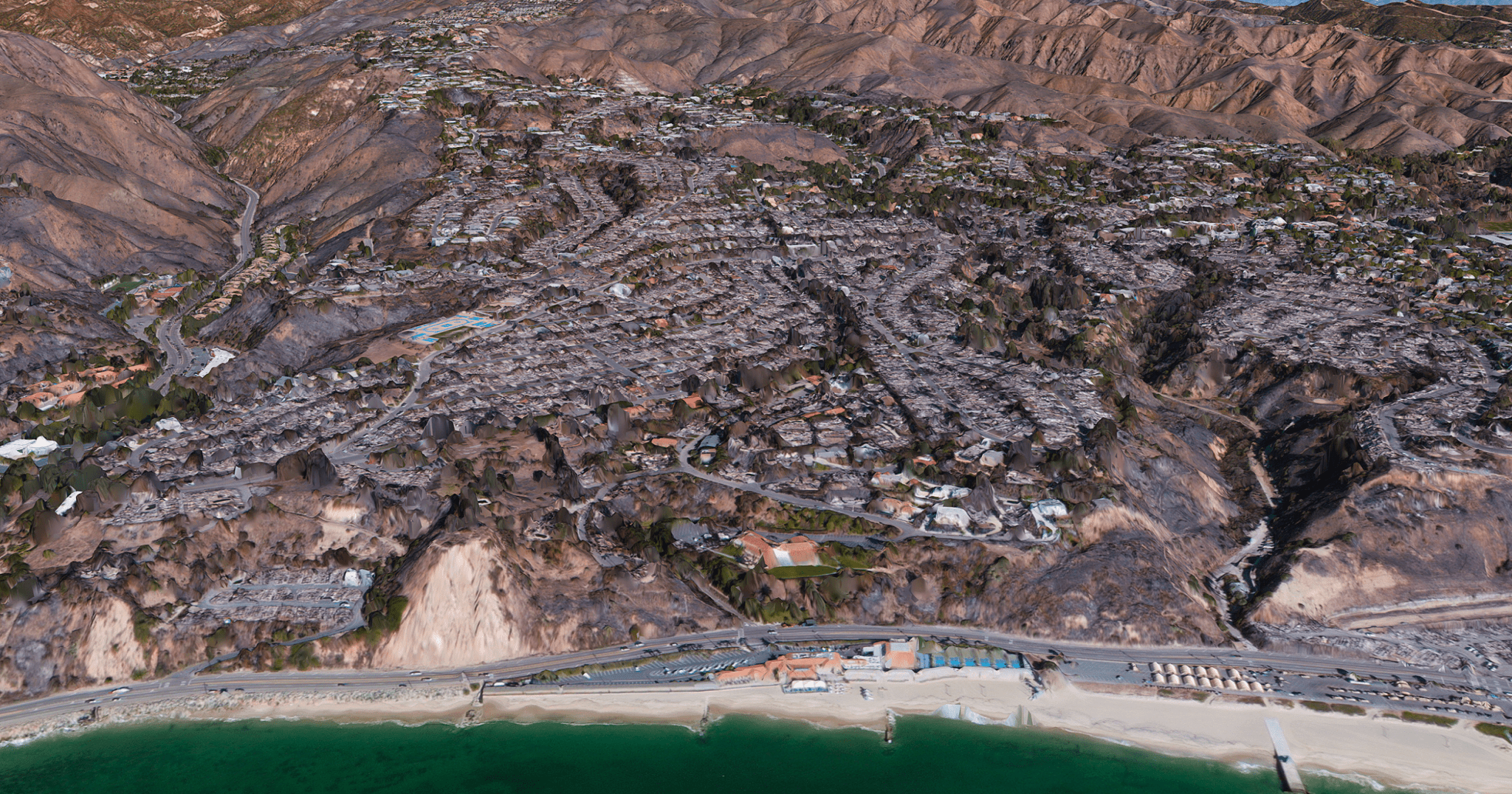
Image: Vantor Vivid Terrain 3D image of a Los Angeles coastal neighborhood after the January 2025 wildfires, showing extensive structural damage and widespread burn scars reaching the shoreline. Credit: Satellite 3D image ©2026 Vantor